Tag Archives: Tift County

Food Pantries 2022-09-18

Jane Fleming Osborn advises:

Food pantries (outdoor boxes attached to buildings or freestanding in an agency/business yard) in this area are up to fourteen.

If you have been blessed, consider refilling the shelves with non perishable foods, personal hygiene items and toiletries to help people experiencing homelessness.

[Pictures of food pantries]
Pictures of food pantries

Continue reading

Most of June electric bill for overbudget nuke, yet the sun rises

While electric bills still are tilted against local solar generation 300x225 CWIP on electric bill, in Most of June electric bill for overbudget nuke, by Bret Wagenhorst, 11 June 2015 and Georgia Power continues to levy its stealth CWIP tax for its nuke boondoggle, yet solar power is rising this year on Southern Company and Georgia Power.

Bret Wagenhorst posted on facebook 9 June 2015:

I find it decidedly ironic that a large portion of my last month electric bill went toward paying for a nuclear power plant that is hundreds of millions of dollars over budget, and which will no doubt cost millions of dollars a year to run and to manage its potentially deadly waste. I wonder if the money spent on the nuclear plant were used to purchase rooftop solar panels for all certified energy efficient Georgian homes if we citizens might not be better off in the long run. Thoughts?

Look for Nuclear Construction Cost Recovery Rider on that bill: Continue reading

Videos: South Georgia Native Plant and Wild Flower Symposium at NESPAL in Tifton GA 2015-03-25

Gretchen took these LAKE videos at the South Georgia Native Plant and Wild Flower Symposium, at NESPAL, UGA, Tifton, GA. The event was sponsored by the University of Georgia and the Garden Clubs of Georgia.

Continue reading

Alternative 4: Richland, Preston, Americus, Cordele, Ashburn and I-75 FERC to Sabal Trail

300x395 Map, in Alternative 4: Richland, Americus, Cordele, Ashburn and I-75 FERC to Sabal Trail, by John S. Quarterman, 14 September 2014 Richland in Stewart County, Preston in Webster County, Americus in Sumter County, Cordele in Crisp County, Ashburn in Turner County, if you thought you were off the Sabal Trail path, think again! You’re in FERC’s eye for a 36-inch fracked methane pipeline just like Tifton, Adel, Hahira, and Valdosta in Tift, Cook, and Lowndes Counties Georgia, and in Florida Jennings in Hamilton County, Lake City in Columbia County, Alachua and Gainesville in Alachua County, Ocala in Marion County, Wildwood in Sumter County, and Ferndale in Lake County, and probably some other cities and counties you can find on the map. And Alternative 4 would cross the Withlacoochee River in Lowndes County just before passing right next to Lowndes High School and an exploding pipeline segment’s throw from Valdosta Mall.

300x386 Withlacoochee River and Lowndes High School, in Alternative 4: Richland, Americus, Cordele, Ashburn and I-75 FERC to Sabal Trail, by John S. Quarterman, 14 September 2014 Alternative 4 in FERC’s recent instructions for Sabal Trail to “include analyses” would start even farther north on I-75 than Alternative 1.

Alternative 4 beginning from Alternate 2 near Richland, Georgia and following Highway 280 to near Americus, Georgia; then following a high voltage transmission line (along Sabal Trail’s Hillabee Alternative route); then following Alternate 1 starting near Tifton, Georgia and extending to the proposed endpoint.

Here’s a very rough map of Alternative 4: Continue reading

Alternative 2: MP 141 -> US 82 -> I-75 -> FL Turnpike FERC to Sabal Trail

Watch out Albany Mall, Deerfield-Windsor School, Kerr Gardens Park and Pond, Miller-Coors Albany Brewery, Pilot Travel Center and of course the Flint River at the US 82 bridge! 300x154 Armena through Miller-Coors Albany Brewery, in Alternative 2: Armena to US 82 to I-75 to FL Turnpike, FERC to Sabal Trail, by John S. Quarterman, 14 September 2014 If Sabal Trail’s mile point (MP) 141 is still on the Lee-Dougherty County line just west of Armena, GA on US 82, then Alternative 2 in FERC’s recent instructions for Sabal Trail to “include analyses” would look very much like Alternative 1, plowing through the north edge of Albany, GA and much of Dougherty County, before heading on through Sylvester, Tifton, Adel, Hahira, Valdosta, Jennings, Lake City, Alachua, Gainesville, Ocala, Wildwood, past The Villages, to Ferndale, FL.

Alternative 2 extending along other pipeline and road rights-of-way from near MP 0 to approximately MP 141 (near Albany, Georgia), and then following Alternate 1 to the proposed endpoint.

Here’s MP 141 in the maps Sabal Trail sent to FERC in November 2013: Continue reading

Alternative 1: US 82 -> I-75 -> FL Turnpike FERC to Sabal Trail

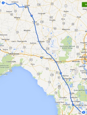
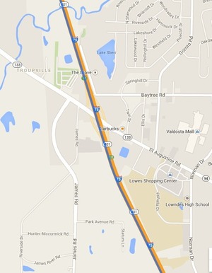
After Dawson and Albany, new Georgia cities Sylvester, Tifton, Adel, Hahira, Valdosta in Georgia (right past Lowndes High School), and Jennings, Lake City, Alachua, Gainesville, Ocala, Wildwood, and Ferndale in Florida. If you thought this pipeline wouldn’t affect you, think again. Or some later pipeline if we let this one through. 
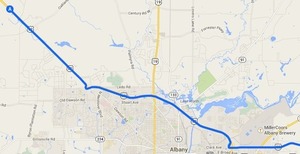
See also Alternative 2 (watch out, Albany!), Alternative 3 Camilla, Thomasville, Monticello, Capps and a row of north Florida counties), and Alternative 4 (Richland, Preston, Americus, Cordele, Ashburn and yet again down I-75 as in Alternative 1).

Update 2014-09-15: Added first paragraph and fixed typos.

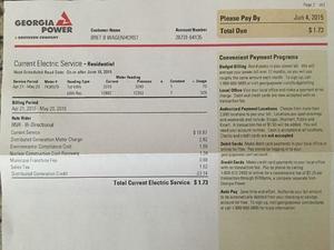
FERC’s recent instructions direct Sabal Trail to “include analyses” of

Alternative 1 Alternative 1 
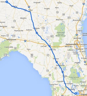
extending from near MP 0 to MP 460.6 (the proposed endpoint) following the Sabal Trail Transmission, LLC (Sabal Trail) proposed Sabal Trail Project (Project) route until reaching Highway 82 near Dawson, Georgia; then following Highway 82 to Interstate 75 (I-75); then following I-75 to Highway 91 near The Villages, Florida; then following Highway 91 to Highway 27 near Ferndale, Florida; and then following a Florida Gas Transmission (FGT) pipeline to the proposed endpoint.

Here’s a very rough map of that route, and then let’s name some cities and towns thus targetted by the yard-wide fracked methane pipeline: Continue reading

Nova Scotia banned fracking; will southeast U.S. ban fracked methane pipelines?

Yesterday Nova Scotia announced a ban on fracking. Will local or state governments in the southeast, now threatened by the Sabal Trail fracked methane pipeline, ban such pipelines? Especially since FERC has now directed Sabal Trail to examine routes through Americus, Cordele, Ashburn, Tifton, Adel, Valdosta, and even Thomasville, in addition to the ones it already proposed through Dougherty, Colquitt, Brooks, and Lowndes Counties?

Sierra Club Canada wrote about public meetings in its Media Release of 28 August 2014, Government of Nova Scotia Needs to Ban Fracking,

“Public meetings held by the panel were attended by an overwhelming majority of well-informed citizens who had deep concerns about fracking,” according to [Gretchen] Fitzgerald, “Those concerns should be met with the type of leadership they deserve: an immediate, legally binding ban.”

And the Nova Scotia government listened. Bruce Erskine wrote for The Herald Business 3 September 2014, Nova Scotia to ban fracking, posting a video in which you can hear Energy Minister Andrew Younger say: Continue reading

Valdosta and Army Corps of Engineers in Flood Risk Management Study

First public update since May: Valdosta has had several recent meetings with other governmental groups and has agreed to co-fund a flooding study by the U.S. Army Corps of Engineers.

WCTV has also picked up Valdosta PR 23 July 2013, City Enters Agreement with USACE for Flood Risk Management Study,

The City of Valdosta hosted a Regional Flood Preparedness meeting with the Georgia Silver Jackets on June 25—a continuation of discussions that began earlier in the year focused on regional interests and on maximizing area resources.

Representatives from the cities of Moultrie, Sylvester, Tifton and Valdosta and from the counties of Lowndes and Turner attended the meeting to discuss current and future flood monitoring and forecasting issues throughout the Little River and Withlacoochee River watersheds. These two watersheds are part of the overall Suwannee Basin that is approximately 10,000 square miles in Georgia and Florida.

Among other information shared, Continue reading

Valdosta Plans Flooding Discussions

Valdosta is finally announcing the 11 April 2013 watershed-wide flooding meeting organized by the Army Corps of Engineers.

WCTV yesterday carried a press release from the City of Valdosta; PR which, oddly, does not appear to be on the city’s website. I have added a few links. Prominently missing from the PR is any mention of water quality, the Floridan Aquifer, or sinkholes. -jsq

The City of Valdosta initiated planning discussions recently that brought together representatives from key local, state and federal agencies to seek solutions to a regional flood issue.

The 50-year flood event that occurred in late February, early March 2013 was a vivid reminder of the 2009 flood event that significantly impacted south Georgia. Since 2009, the city has worked to help identify potential causes and the scope and area of the regional flooding that occurred. This information has been shared with various state and federal officials and agencies in the hopes of gaining their interest and support to work together to address the regional flooding. Since Valdosta is located

Continue reading

Watershed meeting organized by Army Corps of Engineers

The U.S. Army Corps of Engineers (USACE) didn’t know there was a large water problem hereabouts, but now they do, and they want to take a watershed-wide approach, from the headwaters to the Gulf of Mexico, including both surface water and aquifer issues, perhaps starting with redrawing FEMA’s flood maps, and maybe even including once again funding the state water council.

Thursday 11 April 2013 there was a rather large governmental meeting organized by USACE in response to the City of Valdosta’s request of 11 March 2103. Yesterday, Valdosta City Council District 5 Tim Carroll sent the appended list of attendees, augmented by a conversation with him on the phone 13 April and a blog comment by him later that same day on the original post on the WWALS blog, in which he also remarked:

Very good preliminary meeting that hopefully will yield real action on our region wide water issues. Thanks for sharing this info with WWALS.
We know little else, because no media or private citizens were invited.

  • USACE Savannah office: Jeff Morris, Georgia Silver Jackets Coordinator and Beth Williams, Hydraulic Engineer
  • USACE Jacksonville office: David Apple, Chief, Watershed and Restoration Planning Section
  • GADNR: Christopher Hill and Tom Shillock, GAEPD Floodplain Management Unit
  • GEMA: Dee Langley, Planning Program Manager and Terry Lunn, Director, Hazard Mitigation Division
  • GEMA: Gary Rice – Regional Field Coordinator
  • USGS: Brian McCallum, Supv. Hydrologist/ADir and Keith McFadden, Physical Scientist
  • FEMA Region 4: Susan Wilson, CFM, Floodplain Management and Insurance Branch Chief and Janice Mitchell, Insurance Specialist and Lender Compliance

Those state and national agencies were brought by:

Continue reading