Tag Archives: GIS

Videos: Day 2, Planning, Lowndes County Commission @ LCC 2018-02-20

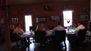
These videos are for those of you who have jobs, or responsibilities, which prevent you from taking random days or hours off at a time. Commissioner Marshall was absent from the second day of the retreat because he has a job which does not allow him the flexibility of daytime hours off. (The first day of the retreat was on Presidents Day.)

The topics of discussion ranged from the ever popular litter and trash collection, to special tax districts, fire and emergency response, animal control and the animal shelter, and one of my favorites, electronic records. Most presentations were made either by the county manager or clerk but the current Deep South Solid Waste Authority Chairman Kevin Beals was first up to talk trash.

Below are links to each LAKE video of Day 2, followed by a LAKE video playlist. See also the LAKE videos of Day 1 and Continue reading

Precincts changed yet again for May 2014 Special Election and Primary

Where can you vote on Tuesday May 20th, Election Day for the Special Election for Lowndes County Commission District 5, for the Lowndes County Board of Education, for the elections for judges, and for the primaries for the Georgia statehouse, statewide offices, and U.S. Congress? Yes, precincts have changed yet again, but you can find your polling place in My Voter Page by the Georgia Secretary of State. Or you can zoom and pan on the VALOR GIS Election Boundary Map.

Whichever way you find your polling place, it’s time to get out and vote. If we don’t, why should Atlanta pay any attention to us poor rural stepchildren?

Continue reading

U.S. Rep. Bishop to listen to landowners about Sabal Trail pipeline

Maybe Lowndes County Commissioners can ask Rep. Austin Scott (GA-08) to do what Dougherty County Commissioners have successfully asked Rep. Bishop (GA-02) to do: those two Congressional districts cover the entire Georgia part of the proposed path of that methane pipeline. And maybe they could help Greenlaw get the FERC scoping period extended and get the GIS data from Sabal Trail.

Carlton Fletcher wrote for the Albany Herald yesterday, U.S. Congressman Sanford Bishop to take part in pipeline listening session: Metting called to address safety, other concerns surrounding controversial natural gas pipeline,

Two Dougherty County Commissioners and one of their former colleagues who is running to rejoin them have scheduled a listening session at 10 a.m. Thursday with U.S. House District 2 Congressman Sanford Bishop to discuss the proposed Sabal Trail Transmission Gas Pipeline project and a planned accompanying Continue reading

GIS maps of Sabal Trail pipeline preferred route

Sabal Trail had an interactive GIS map of the entire pipeline route in Moultrie last night, with zoom and pan detail as good as the tax assessor maps for Brooks and Lowndes Counties. The Sabal Trail reps declined to provide a copy of the whole GIS, but they obligingly panned down the pipeline and waited while I took pictures with my smartphone.

Here’s GIS of the pipeline route through Brooks and Lowndes Counties:

GIS of Brooks and Lowndes Counties

This is zoomed in where the route crosses US 84 and then the Withlacoochee River, which is the county line:

Continue reading

Effects of proposed biomass plants in Massachusetts

Very interesting projection of Massachusetts Forest Impacts if Proposed Biomass Incinerators Are Allowed by Chris Matera, P.E., and Ellen Moyer, Ph.D, P.E., with GIS analysis and programming by Gordon Green:

The animations add the demand for wood for 5 proposed biomass incinerators in Massachusetts to the current wood demand, which is mainly for lumber and cord wood. The animations demonstrate the land area in western and central Massachusetts that would be required to be logged to satisfy the total demand for these 5 plants which would add only about 1 percent to Massachusetts’ electrical generating capacity (see calculations below).

Quite a price for such a small percentage of electricity generation. Solar, wind, and wave could generate far more electricity, even in far northern Massachusetts.

And the animation above is a conservative projection. Follow the link for

…the extreme case where all forested land in central and western Massachusetts would be made available for biomass cutting – including rare species habitat, scenic landscapes, public “protected” land, and other protected open space. In this case, all forested land in central and western Massachusetts would be logged in only 16 years.

In Georgia, that would include places like Reed Bingham State Park.

-jsq