Tag Archives: cypress swamp

Plant the seeds for viable water future

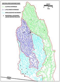
This AJC op-ed is about coastal wetlands, but much of it applies to wetlands such as cypress swamps and streams in Lowndes County and the rest of central south Georgia, especially since our state water plan for the Suwannee-Satilla Region points us at County-Level Population Projections from the Governor’s Office of Planning and Budget that project 45% growth in Lowndes County population in 20 years to 156,650 people by 2030, which means near doubling in 30 years to 2050. -jsq

David Kyler wrote for the AJC 29 December 2006, “Plant the seeds for viable coastal future”,

Recent population projections for the Georgia coast issued by 2010-2030 Change in Population of Georgia Counties Georgia Tech say nothing new. We’re growing at almost 20 percent a decade, meaning a near doubling every 35 years.

The Center for a Sustainable Coast projected a population of about 1 million by 2030 for the 11 counties in the coastal region as defined by the Department of Natural Resources, somewhat higher than the 844,000 predicted by Georgia Tech. This compares with a population of 538,469 reported in the 2000 Census report.

But the accuracy of projections is not the point. Increased population will result in more land clearing and environmental disturbance than in the past—there will be larger homes, bigger lots and fewer people per household.

National studies show up to twice as much land is

Continue reading

Better cities and counties make better watersheds

Want jobs, low taxes, and less flooding? Help maintain our watersheds with good local planning.

What’s a watershed? Kaid Benfield wrote for Atlantic Cities today, The Cost of Sprawl on Clean Water:

Watersheds are topographic areas where all the rain that falls eventually ends up in a namesake steam, river, lake, or estuary.

These are our local watersheds. Purple is the Little River Watershed, blue is the Withlacoochee Watershed, and Valdosta is where the Little River flows south into the Withlacoochee. Green is the Alapaha watershed, and Tifton is where all three meet. Every drop of rain or used well water or wastewater overflow or pesticide runoff or soapy shower water or clearcut mud that runs downhill into one of these rivers is in their (and our) watersheds.

Becoming greener doesn’t just mean a municipality’s adding a pleasant new park here and there, or planting more trees, although both components may be useful parts of a larger effort. How a town is designed and developed is related to how well it functions, how well it functions is related to how sustainable it really is, and how sustainable it is, is directly related to how it affects its local waters and those who use those same waters downstream.

Compact, mixed-use, well-designed in-town growth can take some of the pressure off of its opposite on the outskirts — or beyond the outskirts — of towns and cities. We know that sprawling growth is generally pretty bad for maintaining environmental quality in a region (air pollution from cars that become necessary in such circumstances, displacement of open land, water pollution from new roads and shopping centers that are begot by such growth patterns).

We also know, as UGA Prof. Dorfman told us several years ago,

Local governments must ensure balanced growth, as
sprawling residential growth is a certain ticket to fiscal ruin*
* Or at least big tax increases.

Kaid Benfield explains how town planning is related to watersheds:

Continue reading