Want jobs, low taxes, and less flooding? Help maintain our watersheds with good local planning.
What’s a watershed? Kaid Benfield wrote for Atlantic Cities today, The Cost of Sprawl on Clean Water:
Watersheds are topographic areas where all the rain that falls eventually ends up in a namesake steam, river, lake, or estuary.
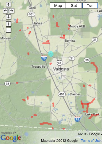
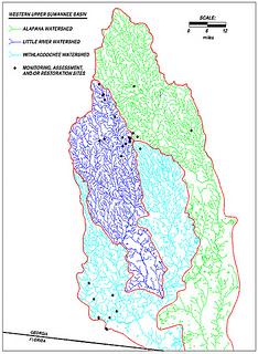 These are our local watersheds. Purple is the Little River Watershed, blue is the Withlacoochee Watershed, and Valdosta is where the Little River flows south into the Withlacoochee. Green is the Alapaha watershed, and Tifton is where all three meet. Every drop of rain or used well water or wastewater overflow or pesticide runoff or soapy shower water or clearcut mud that runs downhill into one of these rivers is in their (and our) watersheds.
Becoming greener doesn’t just mean a municipality’s adding a pleasant new park here and there, or planting more trees, although both components may be useful parts of a larger effort. How a town is designed and developed is related to how well it functions, how well it functions is related to how sustainable it really is, and how sustainable it is, is directly related to how it affects its local waters and those who use those same waters downstream.
Compact, mixed-use, well-designed in-town growth can take some of the pressure off of its opposite on the outskirts — or beyond the outskirts — of towns and cities. We know that sprawling growth is generally pretty bad for maintaining environmental quality in a region (air pollution from cars that become necessary in such circumstances, displacement of open land, water pollution from new roads and shopping centers that are begot by such growth patterns).
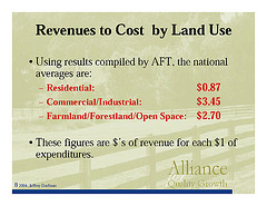 We also know, as UGA Prof. Dorfman told us several years ago,
Local governments must ensure balanced growth, as
sprawling residential growth is a certain ticket to fiscal ruin*
* Or at least big tax increases.
Kaid Benfield explains how town planning is related to watersheds:
Continue reading →
 Two citizens from Hahira couldn’t speak in Citizens Wishing
to Be Heard, but the Chairman
would go into the private board room out of camera range afterwards
to speak to them.
The Chairman did
describe a statement about the Sabal Trail pipeline.
Two citizens from Hahira couldn’t speak in Citizens Wishing
to Be Heard, but the Chairman
would go into the private board room out of camera range afterwards
to speak to them.
The Chairman did
describe a statement about the Sabal Trail pipeline.