 In these videos of
the initial flooding study
by the U.S. Army Corps of Engineers at the Valdosta City Council Work Session,
you can see they’re the Corps, all right: they want to build a levee.
They did emphasize that this was just an initial study on
what could be done inside Valdosta, and their main conclusion
was that there was enough need to indicate federal interest,
as in possibilities of getting federal funding for solutions.
City Manager Larry Hanson got the Corps to confirm (several times)
that Valdosta alone couldn’t stop the flooding, since the vast
majority of floodwaters comes from upstream
on the Withlacoochee and Little Rivers.
In these videos of
the initial flooding study
by the U.S. Army Corps of Engineers at the Valdosta City Council Work Session,
you can see they’re the Corps, all right: they want to build a levee.
They did emphasize that this was just an initial study on
what could be done inside Valdosta, and their main conclusion
was that there was enough need to indicate federal interest,
as in possibilities of getting federal funding for solutions.
City Manager Larry Hanson got the Corps to confirm (several times)
that Valdosta alone couldn’t stop the flooding, since the vast
majority of floodwaters comes from upstream
on the Withlacoochee and Little Rivers.
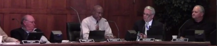
 Later that same evening in response to citizen questions
at the Valdosta City Hall Annex, the Corps clarified more that
they did understand there were issues of impervious surfaces
and development and loss of wetlands and they wanted to
do a much larger study of the entire watershed,
which could take several years to accomplish.
They kept emphasizing that the Suwannee River watershed
is one of the largest in the country, and there are also
flooding problems on the Suwannee River, which could be important
for obtaining federal dollars.
Later that same evening in response to citizen questions
at the Valdosta City Hall Annex, the Corps clarified more that
they did understand there were issues of impervious surfaces
and development and loss of wetlands and they wanted to
do a much larger study of the entire watershed,
which could take several years to accomplish.
They kept emphasizing that the Suwannee River watershed
is one of the largest in the country, and there are also
flooding problems on the Suwannee River, which could be important
for obtaining federal dollars.
As we already knew, Valdosta has funded projects already started to move the Withlacoochee Wastewater Treatment Plant (WWTP) uphill and to add a force main to prevent manhole overflows. People downstream in Florida may be relieved to hear something is being done.
Here’s a video playlist, followed by images of the Corp’s slides and of the City Council, and some notes.
 Videos: Flooding study by Army Corps of Engineers
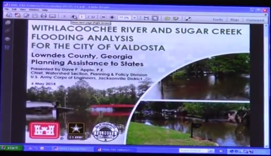
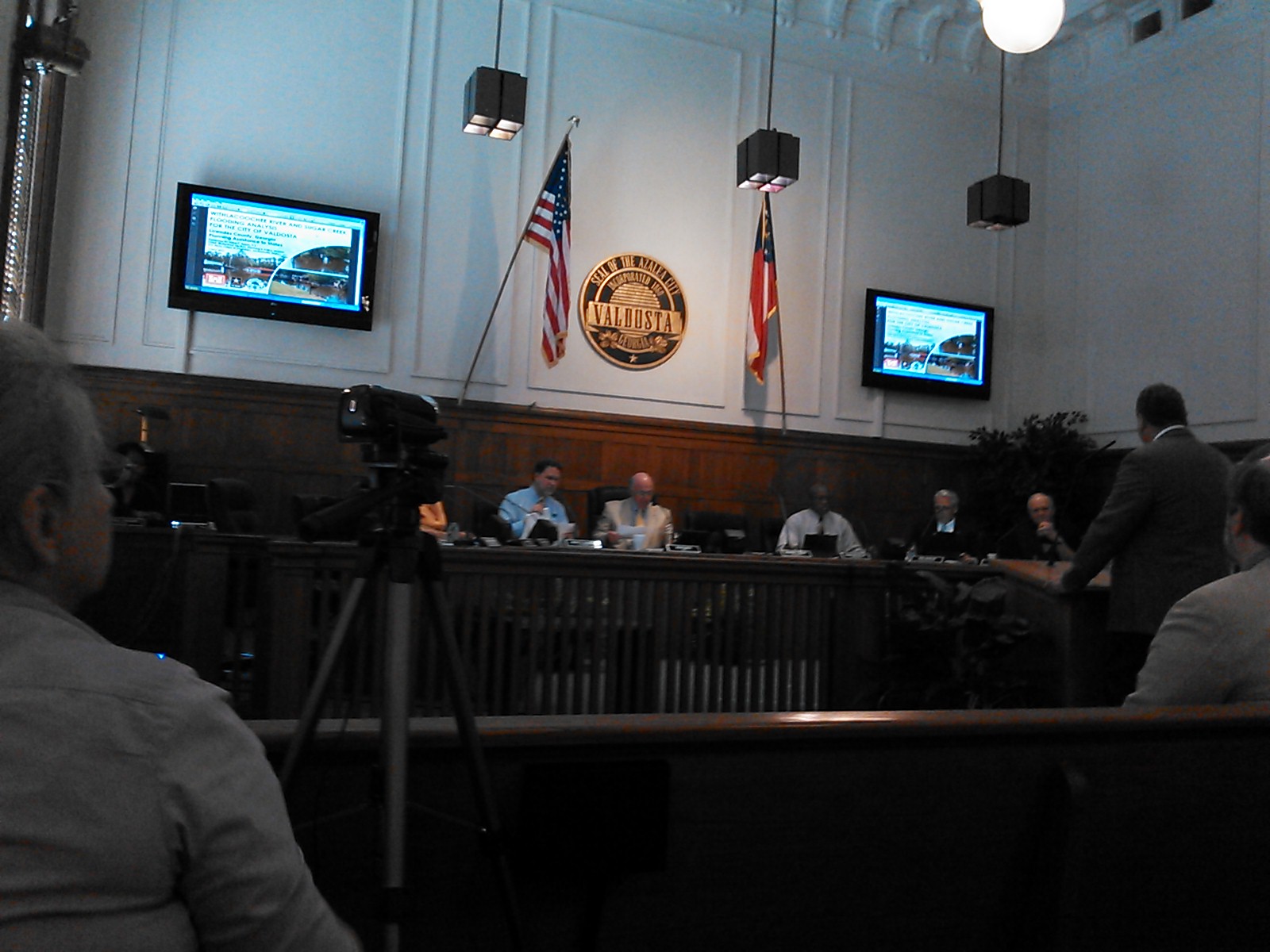
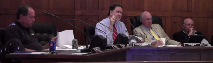
USACE Flooding Study,
Work Session, Valdosta City Council (VCC),
Video by Gretchen Quarterman for Lowndes Area Knowledge Exchange (LAKE),
Valdosta, Lowndes County, Georgia, 6 May 2014.
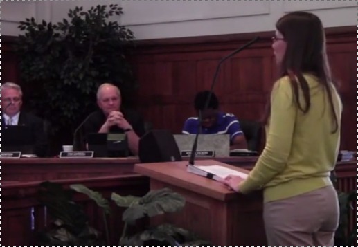 The introduction was by
Emily P. Davenport, Stormwater Manager, Engineering Department, City of Valdosta.
The introduction was by
Emily P. Davenport, Stormwater Manager, Engineering Department, City of Valdosta.
The main speaker was David P. Apple, P.E., Chief, Watershed Planning Section, U.S. Army Corps of Engineers, Jacksonville District.
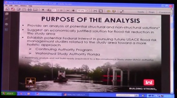 The main purpose of the initial study seemed to be the third bullet point
on that slide:
The main purpose of the initial study seemed to be the third bullet point
on that slide:
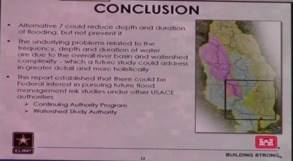
Establish potential Federal interest in pursuing future USACE flood risk management studies related to the study area toward a more holistic approach
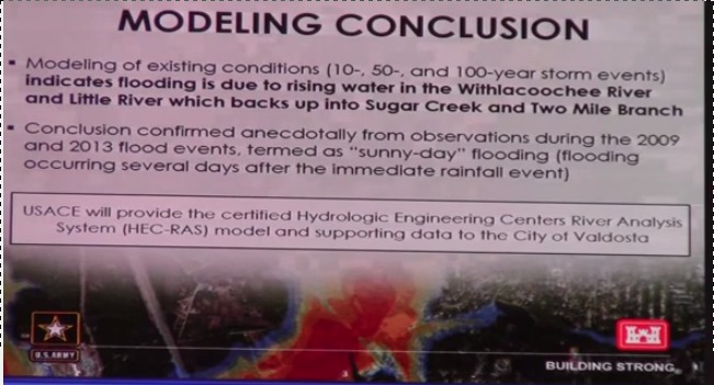 The Corps’ main modeling conclusion was that
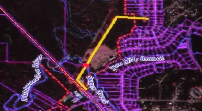
flooding is due to rising water in the Withlacoochee River and Little River which backs up into Sugar Creek and Two Mile Branch.
 There was some discussion of whether water was backing up in the Withlacoochee
River due to the railroad trestle.
Answer: not really, according to recorded flow above and below the trestle.
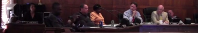
Council Robert Yost (Sugar Creek is in his District 6) asked,
There was some discussion of whether water was backing up in the Withlacoochee
River due to the railroad trestle.
Answer: not really, according to recorded flow above and below the trestle.
Council Robert Yost (Sugar Creek is in his District 6) asked,
You may not have found any structures, but surely the paving of large parking lots and stuff like that didn’t help with the drainage of water around the community?
The Corps’ response was that the problem is from the water coming from upstream on the Withlacoochee and Little Rivers, rising into Sugar Creek and Two Mile Branch.
The water can’t get out. Because of that, it is backing up.
Yost also wanted to know whether the information being presented had ever been looked at that way before. The rather longwinded answer was apparently not, because this study gathered together data from many sources (USGA, National Weather Service, local data, Valdosta’s previous studies, etc.) and modeled it in new ways.
 Council Tim Carroll (District 5) wanted to know on behalf of the citizens,
since 2009 and 2013 obviously are not 700 or even 100 years apart,
Council Tim Carroll (District 5) wanted to know on behalf of the citizens,
since 2009 and 2013 obviously are not 700 or even 100 years apart,
What has happened? What is going on that suddenly in the last four years our city and our community, not just the city of Valdosta, but the county as well, have experienced these flooding situations?
Carroll continued:
Obviously this is just a small picture of the total.
David Apple noted that there was also flooding on the Suwannee at Live Oak, and the Corps wanted to look both upstream and downstream, at all the tributaries. He indicated some of the problems could be infrastructure, or how to manage water, or even drought conditions with sudden rain and runoff.
 City Manager Larry Hanson noted that they wanted to do a followon study.
Apple took the cue and said one of the most important results of
the initial study was it indicated there was a need for a larger study.
City Manager Larry Hanson noted that they wanted to do a followon study.
Apple took the cue and said one of the most important results of
the initial study was it indicated there was a need for a larger study.
 Council Alvin Payton, Jr. (District 4) wanted to know the definition of a watershed.
Various people answered, including Hanson, who said people in
Hahira and Adel and Tifton wanted many of the same answers.
Council Alvin Payton, Jr. (District 4) wanted to know the definition of a watershed.
Various people answered, including Hanson, who said people in
Hahira and Adel and Tifton wanted many of the same answers.
 The simple answer is a watershed is where all the water runs to the same place.
Because of that, local ecologies and communities are bound together by the water.
The simple answer is a watershed is where all the water runs to the same place.
Because of that, local ecologies and communities are bound together by the water.
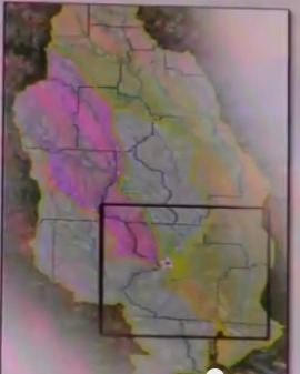 The particular watershed the Valdosta City Council is most interested in
is that of the Withlacoochee River, which starts all the way up in Turner County
and includes water from Colquitt County and Brooks County in addition to
Cook, Berrien, and Tift Counties.
This is the west half of the territory of the
WWALS Watershed Coalition; the complete territory is the same as on the Corps’ Conclusion map (shown on the left here).
The particular watershed the Valdosta City Council is most interested in
is that of the Withlacoochee River, which starts all the way up in Turner County
and includes water from Colquitt County and Brooks County in addition to
Cook, Berrien, and Tift Counties.
This is the west half of the territory of the
WWALS Watershed Coalition; the complete territory is the same as on the Corps’ Conclusion map (shown on the left here).
 The other WWALS half is the watershed of the Alapaha River and its tributaries
the Willacoochee and Alapahoochee Rivers.
Valdosta isn’t as interested in those, since they don’t back up and
flood Valdosta or its other wastewater treatment plant on Mud Creek.
The other WWALS half is the watershed of the Alapaha River and its tributaries
the Willacoochee and Alapahoochee Rivers.
Valdosta isn’t as interested in those, since they don’t back up and
flood Valdosta or its other wastewater treatment plant on Mud Creek.
 The Corps is apparently more interested in the even larger watershed
of the Suwannee River, which includes not only the Alapaha River
but also the Suwannee upstream from the Okefenokee Swamp (which does not
directly affect Valdosta) and downstream, including the Santa Fe
and Ichetucknee Rivers in Florida.
The Corps is apparently more interested in the even larger watershed
of the Suwannee River, which includes not only the Alapaha River
but also the Suwannee upstream from the Okefenokee Swamp (which does not
directly affect Valdosta) and downstream, including the Santa Fe
and Ichetucknee Rivers in Florida.
Council James Wright (District 1) mentioned the difference between a physical model (“a model that you put on the table and it shows how the water flows”) and the type of modelling the Corps was doing.
 Council Carroll mentioned that they’d need much more data for the larger watershed study.
The Corps agreed, and I think they even said they
would take into account vegetation.
Council Carroll mentioned that they’d need much more data for the larger watershed study.
The Corps agreed, and I think they even said they
would take into account vegetation.
Council Carroll wanted to know how loss of natural wetlands affected flooding. Apple answered about the Everglades restoration project, for which they were looking at the effects of agriculture.
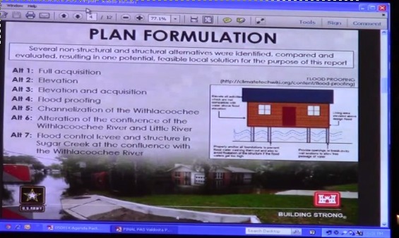
So the Corps looked at seven alternatives for plan formulation:
-
 Full acquisition
- Elevation
- Elevation and acquisition
- Flood proofing
- Channelization of the Withlacoochee
- Alteration of the confluence of the Withlacoochee River and Little River
- Flood control levee and stucture in Sugar Creek at the confluence with the Withlacoochee River
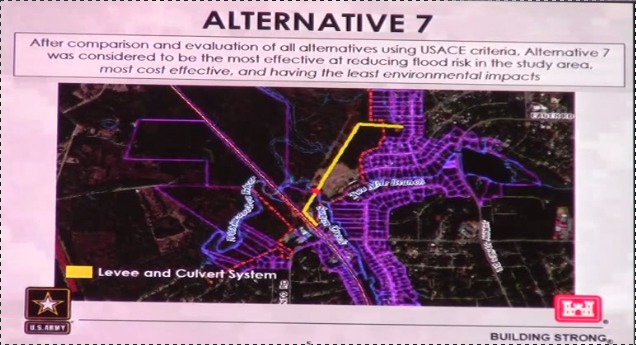
There was some confusion about where the water from Sugar Creek would go when the flood gate on the culvert under the levee was closed.
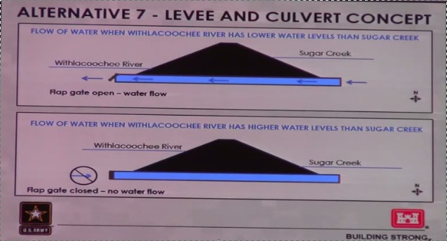
Answer: when the Withlacoochee floods, water can’t get out from Sugar Creek anyway; what the levee would do would be to stop Withlacoochee water from flooding Sugar Creek.
 Mayor John Gayle noted that usually rainfall goes out from Sugar Creek
before the Withlacoochee starts rising from rainfall upstream.
Council Yost said nonetheless if rain falls on Valdosta while
the Withlacoochee is flooding, it can’t get out.
The Corps said that would be the case anyway,
and the levee would stop the Withlacoochee flood water from making
Sugar Creek even worse.
The Council did not seem satisfied.
Mayor John Gayle noted that usually rainfall goes out from Sugar Creek
before the Withlacoochee starts rising from rainfall upstream.
Council Yost said nonetheless if rain falls on Valdosta while
the Withlacoochee is flooding, it can’t get out.
The Corps said that would be the case anyway,
and the levee would stop the Withlacoochee flood water from making
Sugar Creek even worse.
The Council did not seem satisfied.
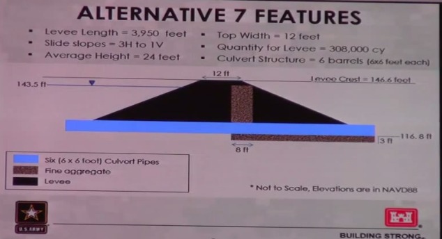
The Corps emphasized freeboard between the maximum expected Withlacoochee floodwater height and the top of the levee to prevent overtopping. Which is a good idea. Unless of course they miscalculated and Sugar Creek turns into the Ninth Ward of New Orleans during Hurricane Katrina.
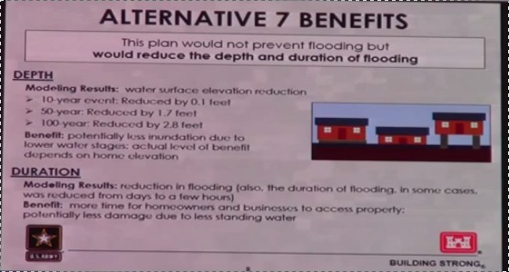
So the benefits of the levee would be to reduce the depth and duration of flooding. This would result in:
more time for homeowners and businesses to access property:
and potentially less damage due to less standing water
A couple of model maps of comparison showed there would still be flooding.
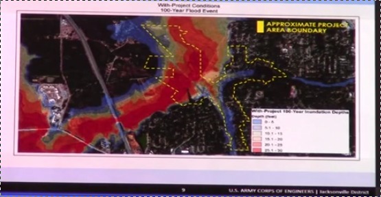
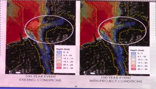
The flooding just would have less effect.

Estimated levee and culvert cost: $3,581,686, not including operation and maintenance.
Benefit to Cost Ratio Estimated to be 1.4.
Council Carroll wanted a timeline for doing the larger study. Answer: about a year to gather the information (data, conversations, etc.), and to find the non-federal partners such as the states of Florida and Georgia. The Congressional members for Florida and Georgia could push for a watershed study to authorize the Corps to do it. Later across the street at the Annex I think David Apple said the actual study could take about four years.
-jsq
Short Link:
Pingback: May WWALS Board Meeting at the Gaskins Forest Education Center | WWALS Watershed Coalition
Pingback: Study before Levee --Tim Carroll | WWALS Watershed Coalition