Tag Archives: Planning

Proposed Solar Plants

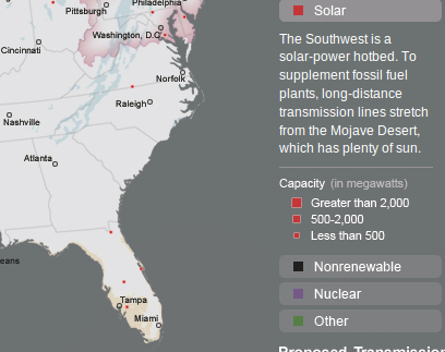
OK, let’s look at “solar” in the online interactive map from Joel Achenbach’s story about The 21st Century Grid in the July 2010 National Geographic. It’s easy to count the proposed solar power plants in Georgia: zero. Yet there’s one in Virginia, one in Maryland, and at least three in Florida, adding to the currently largest solar plant in the country near De Soto, Florida. The map legend repeats the GEFA canard that
The Southwest is a solar-power hotbed. To supplement fossil fuel plants, long-distance transmission lines stretch from the Mojave Destert, which has plenty of sun.
Yes, that’s true, but what about this. At least three solar plants are proposed around San Antonio and Austin, which are not in the area of the southwest the map blurb is referring to. In fact, the largest solar plant in the country is proposed for Austin. Austin is one degree of latitude south of Valdosta, and has been leading the country in solar deployment for many years now. Texas in general almost doubled renewable energy generation between 2004 and 2006 while Georgia did nothing. Texas hasn’t stopped. When will Georgia start?

The Austin solar solution doesn’t require massive new power lines, either. It’s mostly been accomplished with solar panels on houses and business roofs; panels that wouldn’t show up on National Geographic’s map because they’re small and distributed. Which is the point: they generate power where it’s needed, and at peak times when it’s needed, namely when it’s hot and sunny out and air conditioners are running on max. There’s no reason Georgia can’t do the same.

I would continue this series by showing wind generation proposed for Georgia, but there isn’t any of that, either. There could be, off the coast.

Which makes more sense: polluting our air with more coal and biomass plants, or getting a move on with solar and wind?

-jsq

Proposed Biomass Plants

Let’s select “other” in the online interactive map from Joel Achenbach’s story about The 21st Century Grid in the July 2010 National Geographic. This map clearly shows the proposed Wiregrass LLC plant in Valdosta, as well as two plants proposed just to the south for Hamilton County, Florida, and one in Echols County, Georgia, which presumably would be the Oglethorpe Power alternative site. Several of the other plants shown are probably the other proposed Oglethorpe Power plants. Missing is Georgia Power’s Plant Mitchell in Albany, which is supposed to convert from coal to biomass. (Also if you select “nuclear”, the two Georgia Power proposed nuclear plants on the Savannah River are missing.) Apparently National Geographic edoesn’t have a complete list of proposed biomass plants. I wonder who does, if anybody?

Nonetheless, take this map of proposed biomass plants and combine it with the map of proposed new coal plants, plus the existing coal plants in Juliette, Georgia (dirtiest in the country) and Albany, and south Georgia is slated to become even more infested with polluting energy sources.

Does that seem like a good idea to you?

Next: proposed solar plants.

-jsq

Proposed Coal Plants

In the July 2010 National Geographic, Joel Achenbach writes about The 21st Century Grid. It’s mostly about how we need a smart grid and additional power lines to redistribute power better, but it does get into proposed power plants to generate new power.
Although everyone acknowledges the need for a better, smarter, cleaner grid, the paramount goal of the utility industry continues to be cheap electricity. In the U.S. about half of it comes from burning coal. Coal-powered generators produce a third of the mercury emissions in America, a third of our smog, two-thirds of our sulfur dioxide, and nearly a third of our planet-warming carbon dioxide—around 2.5 billion metric tons a year, by the most recent estimate.
Then it talks about how it’s hard to get stodgy electric utilities to invest in anything else. However, there is at least one way:
A California law requires utilities to generate at least 20 percent of their electricity from renewable sources as of this year.
OK, so what new energy plant are proposed for Georgia? The online interactive map lets you select different energy types. The map above shows four proposed new coal plants in Georgia, surrounding south Georgia (plus something nonrenewable in Florida near Tampa). I recognize the one in far southwest Georgia as the one proposed for Early County and fortunately still tied up in litigation. All four are in addition to the existing Plant Scherer at Juliett, GA, near Macon, the dirtiest coal plant in the country, and the one that generates 2/3 of our power for south Georgia (as well as selling a lot of power to Florida). Adding still more dirty coal plants does not look like progress.

Continued in next blog entry.

-jsq

Nix on biomass plant in Traverse City, Michigan

Looking farther afield in Cadillac, Michigan than schools and realtors, there are some people who aren’t completely pleased with the local biomass plant:
Complaints are more frequent along Mary Street, a short stretch a few hundred yards south of the plant. Residents there deal with more intense noise and odors.

Craig Walworth’s home is among the closest to the plant. He walked up to his Jeep — a vehicle he cleaned the day before — and dragged his finger through a layer of film on the hood.

“Every morning, you have that to look forward to,” he said. “I clean my screens three times a year during the summer because they clog up.”

Nonetheless he didn’t say it affected his property values. However, that’s not the only issue.

Meanwhile, about an hour north on the edge of Lake Michigan, in Traverse City local activism caused cancellation of a proposed biomass plant: Continue reading

Greyfield Villas

Entrance sign Previously discussing the Glen Laurel subdivision on Old Pine Road near Bemiss, several of the people speaking against at the County Commission meeting mentioned the Greyfield subdivision. That’s Greyfield Villas; see the entrance sign in the picture on the right. It’s in Lowndes County but not in Valdosta; somebody correct me if I’m wrong abo ut that. In that picture it’s hard to read the sign in the background on the north side of North Oak Street Extension. Here’s a closeup:

FOR RENT by Blake Taylor

For Rent. Just inside we see a dumpster with For Rent signs on the houses on either side: Continue reading

Highland Renewable Energy Strategy

Previously writing about biomass and carbon dioxide I said I’d supply an example of the sort of thing I’m looking for as a regional analysis for renewable energy, including biomass, solar, wind, wave, tides, and others. Here it is: the Highland Renewable Energy Strategy approved by the Highland Council at its 4 May 2006 meeting. It’s a 58 page document about renewable energy strategy and planning guidelines, considering numerous types of renewable energy, pros and cons of each, power distribution, effects on environment, protected areas, etc., illustrated copiously with detailed maps. And updated: Continue reading

Green Exercise for Mental Health

Quantifying something we can all feel:
ScienceDaily (May 1, 2010) — How much “green exercise” produces the greatest improvement in mood and sense of personal well-being? A new study in the American Chemical Society’s semi-monthly journal Environmental Science & Technology has a surprising answer.

The answer is likely to please people in a society with much to do but little time to do it: Just five minutes of exercise in a park, working in a backyard garden, on a nature trail, or other green space will benefit mental health.

All natural environments were beneficial including parks in urban settings. Green areas with water added something extra. A blue and green environment seems even better for health, Pretty noted.
Here’s a link to a news blurb in the journal:
Pretty says that his goal with this study is not to provide just another recommendation for individuals but to provide data that can be used in policy discussions. Those data “could translate into what the landscape guidelines are for schools or for public housing,” says Nancy Wells, associate professor of community ecology at Cornell University.
Here is a link to the actual article.

Is all development good?

What to do with Detroit? Cindy Perman writes for CNBC:
Mayor Dave Bing is apparently working on a radical plan that would bulldoze a quarter of the city — some of the most desolate areas — and return it to farmland, the way it was before the automobile. Any residents still there would be relocated to stronger neighborhoods.

Dan Kildee, treasurer of Genessee County, containing Flint, Michigan, remarks:

“The obsession with growth is sadly a very American thing. Across the US, there’s an assumption that all development is good, that if communities are growing they are successful. If they’re shrinking, they’re failing.”
Actually, building more subdivisions just increases the deficit between tax revenues collected and cost of services provided.

Perman concludes:

Welcome to the future. Why does it look so much like 1910 instead of 2010?
Perhaps because 1910 had railroads for mass transit and cities were still dense and close to existing services?

Transportation Plan Open House, MPO

The Valdosta-Lowndes County Metropolitan Planning Organization is holding an open house about its Long Range Transportation Plan. (Not to be confused with the County’s Thoroughfare Plan, which has little or no open process.) This Transportation Plan I think will include another attempt to design a bus system; we’ll see. I’ll be there; how about you?

Here’s a transcription of the PDF flyer:

PARTICIPATE! PARTICIPATE! PARTICIPATE!

Public Open House

Wednesday, February 17, 2010
3:00 PM to 5:00 PM

at the
Southern Georgia Regional Commission
327 W. Savannah Avenue, Valdosta, GA

2035 Valdosta-Lowndes MPO
Long Range Transportation Plan Draft Project List Review

Valdosta-Lowndes MPO
229-333-5277 … chull@sgrc.us … www.sgrc.us/transportation

Where and why flooding happens

Michael E. Kanell and Ty Tagami, writing in the AJC about More than 16,000 flood-related claims filed in Atlanta area, quote Robert Klein, professor of risk and insurance at Georgia State University:
Moreover, the maps that set out those high-risk areas are “woefully inadequate,” he said.

Maps should be recalibrated to account for continued development and sprawl, he said: destruction of trees, paving of roads and parking lots, addition of new homes to older areas and landscaping all change the way water drains — or doesn’t drain.

And maybe somebody should do something about that continued development and sprawl.