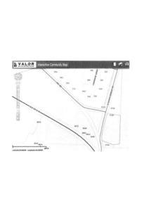
 Looks like the 5720 S. Hagan Bridge address is in
VALOR GIS map for
the Hahira extraterritorial request
in the
board packet, which appears to have been received as an attachment to
the request letter from Hahira.
It’s easier to see if you go directly to
VALOR GIS
and zoom in.
Which raises the question of why is the address in VALOR GIS
different from the address in the
Tax Assessors map.
Looks like the 5720 S. Hagan Bridge address is in
VALOR GIS map for
the Hahira extraterritorial request
in the
board packet, which appears to have been received as an attachment to
the request letter from Hahira.
It’s easier to see if you go directly to
VALOR GIS
and zoom in.
Which raises the question of why is the address in VALOR GIS
different from the address in the
Tax Assessors map.
See also this comment today by Barbara Stratton. -jsq
Mr. Allen said 5720 S Hagan Bridge Rd, which is the agenda address I was also given by one of the County Commissioners Tuesday afternoon. 5710 S Hagan Bridge Rd is the address in the Tax Assessors records and also the address that was approved by the Hahira City Council in previous meetings. So where did the 5720 address come from and I also agree that the correct address and owner name should have been published for public record. The 5710 property owned by John Bailey was purchased in February 2014 and almost immediately the Hahira City Council was approached about furnishing water/sewer to the property. The 1.83 acre piece of property which was listed as a mobile home sale seems a pretty innocuous water/sewer request.
However, once the water/sewer is furnished by the city it would not be hard to imagine another seemingly innocuous request to annex said property into the city which could make a profitable gateway to possible annexation of some or all of the 200 plus acres of adjacent properties currently vested in a lifetime estate and probably open for investment. Just a thought to go with the address confusion already cited. Wouldn’t it be nice if all the cards were always just laid out on the table so we did not have to guess and speculate.
I’ve been told the lack of information is just good strategy on the part of developers. I personally would like to go back to the days when integrity and honesty were more important than strategy.
-Barbara Stratton
Short Link: