This is the entrance to I-75 from GA 122 that often is backed up all the way to the traffic light in Hahira in the morning, that I use all the time. It did change quite a bit way back in 2006. More concerns were raised by citizens in 2013, but “No major changes made as a result of comments received.” One archaeological site was found in a survey. The winning bid for each of the utilities relocation and the main contract was Reames.
GDOT PR, 2017-08-25, Lowndes County: Reconstruction of I-75 Exit 29 Starts Monday,

VALDOSTA — Changes that will impact traffic are coming to Interstate 75 at Exit 29 next week as a Georgia Department of Transportation contractor begins reconstruction of the interchange.
Exit 29 is SR 122 at Hahira. The north and south outside (right) lanes approaching the exit will close at 7 p.m. Monday and reopen before 7 a.m. Tuesday. The outside lanes will reopen once the barrier is in place, but the outside shoulders between the entrance and exit ramps will remain closed for construction of the new overpass.
Construction will also require closing the inside (left) north and south lanes to traffic approaching and traveling under the bridge. The contractor will begin installing a concrete barrier in that location at 7 p.m. Tuesday. This will close the north and south inside lanes and shoulders for the duration of construction. Motorists should expect to see heavy equipment in the area, including a crane, as construction progresses. Motorists will also start seeing right of way clearing at both exits and utility companies on site as they relocate lines, poles, etc.
Reconstructing Exits 29 and 22 will improve traffic flow and capacity and improve visibility for drivers exiting the ramps. The bridges were built in 1960 and the design is outdated for current and projected traffic. Bridges will be widened to four lanes with turn lanes, paved shoulders and concrete medians. Northbound ramps at Exit 22, U.S. 41/SR 7/North Valdosta Road near Valdosta, will be reconstructed as a conventional diamond design. Southbound ramps will remain as is. At Exit 29, all ramps will be a conventional diamond design.
The new bridges will be built adjacent to the existing overpasses, which will not close during construction. Georgia DOT awarded the construction contract to Reames and Son Construction Co. Inc. of Valdosta in June. The completion date for the two interchanges is April 30, 2020 and the construction cost is $49 million.
#
2013-10-24: VLMPO held open houses about this project four years ago.
2014-05-16: GDOT Approved Location & Design Report for “I-75 Improvements from North of SR 133 to the Cook County Line”, including
Interstate 75(SR 122 (Main Street) Interchange Exit 29
The I-75/SR 122 (Main Street) Interchange, Exit 29, reconstruction begins on Main Street just east of the Frank’s Creek bridge approximately 1782 feet west of Us. With proposed improvements, the existing two- lane SR 122 would transition to and become two eastbound lanes and one westbound lane separated by a variable width flush median with rural 6 1/2-foot outside paved shoulders approaching the intersection of relocated Morven Road and a proposed access road serving the parcels of land on the north side of SR 122 approximately 986 feet west of HS SR 122 would continue as a four-lane divided roadway with a 20-foot raised concrete median and rural 6 1/Z-foot outside paved shoulders to the intersection of relocated Union Road approximately 1063 feet east of I-75. SR 122 would continue as one lane in each direction separated by a variable width flush median. The I-75/SR 122 Interchange reconstruction on Main Street ends approximately 1848 feet east of I-75 where the project would tie to the existing two—lane rural roadway.
The project would include a new bridge over I-75 and reconstruct the I-75 ramps as a conventional diamond interchange. Approximately 0.7 miles of Morven Road (CR 782) and 0.7 miles of Union Road (CR 38) would be relocated to intersect reconstructed SR 122 to provide maximum median opening spacing with the proposed I-75 ramps while minimizing impacts to the surrounding area.
Either GDOT or Lowndes County or both has been trying to do this for a long time:
Concept Approval Date: October 19, 1999 under Project NH-75-1l203) Lowndes County Phase II August 17, 2007 Approved Revised Concept Report
A bit farther down:
Public Involvement:
Hearing results: A public hearing is not required
- Public Information Open House results:
- A public information open house was held on September 5, 2006 at Vaidosta Technical College, 4089 Val Tech Road, Bldg 500, Valdosta, Georgia 31602-0929
- Concerns regarding economic impact on the community and need for proposed traffic light at the Shiloh Road/Val Tech Rd intersection.
- Eleven comment forms and no verbal comments at meeting with twelve additional comments received during ten day period September 5, 2006 to September 15, 2006.
- Comment Summary: 9 support, 4 conditional, 1 uncommitted and 9 opposed
- Attendees: total 30, 7 public officials
- The major change made as a result of comments received is the redesign of the my SR 122 Interchange to a conventional diamond interchange which resulted in reducing the construction limits on the west side of l-75 by approximately 510 feet thus eliminating the widening of the Franks Creek bridge and on the east side of I-75 by approximately 646 feet. The use of retaining walls at the bridge end bents resulted in proposed ramp and relocated Morven Road and Union Road alignments that reduced required right of way impacts.
- …
- A third public information open house was held on December 17, 2013 at Wiregrass Georgia Technical College, 4089 Val Tech Road, Bldg 500, Valdosta, Georgia 31602-0929
- Concerns for proposed concrete median that affects access to existing businesses along 5.R. 122, to add Interchange lighting in project and provide a timeline for the proposed project.
- Three comment forms and three verbal comments (one of which also filled out a comment card) at meeting with one additional comment received during ten day period December 17, 2013 to January 2, 2014.
- Comment Summary: 1 support, 2 conditional, 3 uncommitted and 0 opposed
- Attendees: total 37, 4 public officials
- No major changes made as a result of comments received.
2016-??-??: Billy J. Mccarley for Moreland Altobelli Associates, Inc., some time in 2016, Abstract
Moreland Altobelli Associates, Inc (hereafter called MAAI) performed a second addendum Phase I archaeological survey of two interchanges (SR 7 and SR 122) along Interstate 75 (I-75) in September 2016. This archaeological survey was conducted to comply with Section 106 of the National Historic Preservation Act (NHPA) of 1966, as amended, implementing 36 CFR Part 800 for guidance. The survey was conducted to locate and identify archaeological resources and to assess resource significance based on National Register of Historic Places (NRHP) criteria [36CFR Part 60.4 (a-d)]. The field survey and report were completed using the Georgia Department of Transportation’s (GDOT) Environmental Procedures Manual (2010) and the Georgia Council of Professional Archaeologists Standards and Guidelines for Archaeological Surveys (2014).
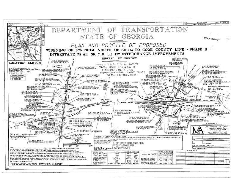
Project NHS00-0000-00 (762), Pl No. 0000762 is Phase II of Project NH-75-1(203), Pl No. 410500 the 13.40 mile widening of 1-75 from north of SR 133 to Cook County Line in Lowndes County, Georgia. Phase II proposes to widen 1.0 mile of SR 7 (Shiloh Road/N Valdosta Road) and 0.7 mile of SR 122 (Main Street) and reconstruct their interchanges with 1-75. The 1-75/ SR 7 Interchange, exit 22, is located approximately 4 miles northwest of the City of Valdosta, Georgia. The 1-75/ SR 122 Interchange, Exit 29, is located within the westernmost city limits of Hahira, Georgia.Interstate 75/SR 7 (Shiloh Road/North Valdosta Road) Interchange Exit 22
The 1-75/SR 7 (Shiloh Road/North Valdosta Road) interchange, Exit 22, reconstruction would begin on Shiloh Road just east of the Frank’s Creek bridge approximately 3,322 feet west of 1-75. With proposed improvements, the existing two-lane Shiloh Road would transition to and become a four-lane divided roadway with a 20-foot raised concrete median and rural 6 1/2-foot outside paved shoulders. The existing 1-75 southbound ramps constructed under Project NH 75-1(203), P.I. No. 410500 would be tied to the proposed SR 7 improvements. The project would include a new bridge over 1-75 and reconstruct the 1-75 northbound ramps as a conventional diamond interchange. The 1-75/SR 7 interchange reconstruction on SR 7 (N. Valdosta Road) would end just east of the existing signalized intersection at Coleman Road (CR 553) approximately 1953 feet east of 1-75 where the project would tie to the existing four-lane divided rural roadway with a 40-foot depressed grass median. Existing ROW along SR 7 varies between 50 and 80 feet. Existing ROW at the I-75/SR 7 intersection varies between 250 and 300 feet
Required ROW along SR 7 varies between 60 and 100 feet. Required ROW at the I-75/SR 7 intersection varies between 350 and 400 feet.
Interstate 75/SR 122 (Main Street) Interchange Exit 29
The 1-75/SR122 (Main Street) Interchange, Exit 29, reconstruction would begin on Main Street just east of the Frank’s Creek bridge approximately 1782 feet west of 1-75. With proposed improvements, the existing two-lane SR 122 would transition to and become two eastbound lanes and one westbound lane separated by a variable width flush median with rural 6 1/2-foot outside paved shoulders approaching the intersection of relocated Morven Road and a proposed access road serving the parcels of land on the north side of SR 122 approximately 986 feet west of 1-75. State Route (SR) 122 would continue as a four-lane divided roadway with a 20-foot raised concrete median and rural 6 1/2-foot outside paved shoulders to the intersection of relocated Union Road approximately 1063 feet east of 1-75. State Route (SR) 122 would continue as one lane in each direction separated by a variable width flush median. The 1-75/SR122 Interchange reconstruction on Main Street ends approximately 1848 feet east of 1-75 where the project would tie to the existing two-lane rural roadway.
The project would include a new bridge over 1-75 and would reconstruct the 1-75 ramps as a conventional diamond interchange. Approximately 0.7 miles of Morven Road (CR 782) and 0.7 miles of Union Road (CR 38) would be relocated to intersect reconstructed SR 122 to provide maximum median opening spacing with the proposed 1-75 ramps while minimizing impacts to the surrounding area. Existing ROW along SR 122 is 50 feet. At the I-75/SR 122 intersection, existing ROW varies between 250 and 300 feet. Required ROW along SR 122 is 80 feet, and required ROW along Morven Road realignment is 100 feet.
The proposed project area was surveyed in 2007 by Ground Truth Research and again in 2008 when slight changes were made to the Union Road realignment (Stoops 2007, 2008). In early September 2016, MAAI archaeologist Billy McCarley reviewed the areas previously surveyed in 2007 and 2008 and determined that certain areas of the APE were not properly assessed in 2007 or 2008. Therefore, MAAI returned to the project area and surveyed all existing ROW. In addition, MAAI determined that required ROW and construction easements along Flythe Road, Shiloh Road west of Golden Oaks Drive, Shiloh Road east of Val Tec Drive, the southern portion of the Morven Road realignment, the southern portion of Union Road realignment, an unnamed road west of Morven Road along Main Street, and the eastern portion of Main Street needed to be assessed and shovel tested. Because the original surveys in 2007 and 2008 were based on GDOT survey standards of 2007 and 2008, Ground Truth Research did not survey the Expanded Survey Corridor (ESC). Therefore, because an ESC was not required during the original survey, MAAI did not survey the ESC during this second addendum survey.
The entire project area was inspected for archaeological materials. Fifty-one negative shovel tests were performed along Flythe Road, Shiloh Road west of Golden Oaks Drive, Shiloh Road east of Val Tec Drive, the southern portion of Union Road realignment, the eastern portion of Main Street, and along the southern portion of the Morven Road realignment. No shovel tests were positive.
However, one site (9LW174) was discovered on the surface along the southern portion of the Morven Road realignment. The site is a late nineteenth to early twentieth century historic scatter with a minor precontact component. Site 9LW174, which spans adjacent to Morven Road in a cultivated field, occurs completely within the APE. The site is approximately 100 m long by 20 m wide. Because the artifact scatter was identified on the surface, walking transects 5 meters apart were executed along the site to identify the extent of the artifact scatter and to collect artifacts. Then, close-interval shovel tests are performed; however, none of the shovel tests were positive for cultural materials or features. The portion of the cultivated field associated with the site was thoroughly inspected in four directions and shovel tested within and outside the APE. These methods confirmed that the site ceased inside the APE. Shovel testing within the site revealed a thick plow zone (20 cmbs) that was sterile of artifacts or features.
Because of the thick plow zone, the site appears heavily disturbed by cultivation. Because the site lacks depositional integrity and does not contain sufficient data that would lead to future research, MAAI recommends the site ineligible, and no further work is needed.
Report Number
9295Year of Publication
2016County
Lowndes
2017-04-11: The Lowndes County Commission discussed utility relocation for this project on 10 April 2017 and approved that on 11 April 2017, to the tune of $684,515.30, with work to be done by GDOT and reimbursed by the county. They also approved a contract for the county to mow all the I-75 exits with GDOT reimbursing the county.
2017-05-19: Valdosta Daily Times, 19 May 2017, Lowndes tapped for I-75 facelift,
VALDOSTA — Lowndes County has been approved for two revamped Interstate 75 overpasses and exits, according to the state Department of Transportation.
A $46 million construction project to rebuild and improve two heavily traveled I-75 interchanges in Lowndes County is scheduled to be advertised for bid following approval Thursday by the State Transportation Board, according to a state press release issued Friday.
The Georgia Department of Transportation project to reconstruct Exits 22 and 29 will be made available for bid June 16. The award to the lowest qualified bidder is expected to be announced by the end of June….
Exit 29 is the state Route 122/Main Street interchange at Hahira and Exit 22 is U.S. 41/SR 7/North Valdosta Road near Valdosta.
The bridges were built in 1960 and the design is outdated for current and projected traffic, Golden said.
The bridges are narrow, which makes it difficult for motorists at the top of the ramps to see oncoming traffic, according to state officials. Both routes are two lanes and SR 122 doesn’t have turn lanes. A short SR 7 westbound turn lane for traffic to go south on I-75 often backs up, which blocks through traffic.
The project will widen both bridges to four lanes with turn lanes, paved shoulders and concrete medians and will reconstruct the ramps. This will improve traffic flow and capacity and improve visibility exiting the ramps.
It is the latest of 16 bridge replacements in Southwest Georgia that were awarded within the past 12 months or are scheduled to be advertised for bid this year, according to the DOT press release. Structurally deficient and/or functionally obsolete bridges on and off the state highway system are being replaced with structures that meet current Georgia DOT guidelines.
Many of the aging bridges are in rural areas. Replacing them is good for rural Georgia where farmers and agricultural-based industries need to move products to market, Commissioner Russell McMurry noted. Some bridges that are being replaced have posted weight limits due to deterioration. One was ordered shut down by Georgia DOT.
2017-06-16: Moreland Altobelli Associates, Inc., SOIL SURVEY REPORT, CALL ORDER # 5, NHS00-0000-00 (762), LOWNDES COUNTY, JUNE 16, 2017 LETTING,
SOIL SURVEY SUMMARY
SR 7 and SR 122 over I-75
Lowndes County, Georgia
Project No. NHS00-0000-00(762)
Georgia DOT P.I. No. 0000762
1. Location /
DescriptionThis project is for the intersection improvements/constructions of SR 7 (North Valdosta Road) and SR 122 (Main Street) over Highway I-75. The improvements include construction of ramps and side streets (see attached location map). The project lies north of the city limits of Valdosta in Lowndes County. 2. Geology This project will be geologically sited in the Miccosukee Formation of the Georgia Coastal Plain . 3. Removal The soils near the proposed grade in the following areas were found to have in-place moisture contents far above the optimum moisture contents. This condition has the potential to cause severe pumping problems during subgrade and base construction. After excavation in these areas is complete, we recommend that 24 inches of subgrade soils beneath the pavement and shoulders be removed and either dried out and replaced, or replaced with drier soils:
Much more detail is included in this 31-page report, which is on the LAKE website.
2017-07-15: Larry Godwin, AllOnGeorgia, 15 July 2017 Georgia DOT Awards Lowndes I-75 Interchange Projects,
The Georgia Department of Transportation has awarded the reconstruction of two Lowndes County Interstate 75 interchanges at a cost of $48.4 million with a completion date of April 30, 2020.
Reames and Son Construction Co. Inc. of Valdosta was the lowest qualified bidder on the project that will improve the interchanges of Exits 22 and 29. No construction start date has been determined. The overpasses will not close and construction will be staged to avoid long-term detours.
Exit 22 is U.S. 41/SR 7/North Valdosta Road/Shiloh Road near Valdosta and Exit 29 is SR 122/Main Street at Hahira. The project was advertised for bid in May and the contract was awarded June 30….
Reconstruction of most I-75 interchanges in southwest Georgia is in the Georgia DOT work program. The next two interchanges slated for reconstruction are Exits 2 and 11. The Department is proposing to advertise the project for bid in 2019.
The Exit 22 and 29 project was the largest single monetary contract awarded in June, but it was not the only one that will benefit southwest Georgia.
That story does not give any source, but according to BidExpress List of Lettings for GDOT Proposal B1CBA1701423-0, the Apparent Bids were two:
| REAMES AND SON CONSTRUCTION COMPANY, INC. | $48,471,167.45 |
| THE SCRUGGS COMPANY | $53,439,293.95 |
And Reames was the low bidder.
-jsq
Investigative reporting costs money, for open records requests, copying, web hosting, gasoline, and cameras, and with sufficient funds we can pay students to do further research. You can donate to LAKE today!
Short Link:
Pingback: Videos: Crowd for three rezoning cases @ GLPC 2017-07-31 | On the LAKE front