 See for yourself the Tax Assessor response to local landowners, in these
LAKE videos of
last night’s meeting at Farm Bureau.
Do you think there’s a problem?
If so, what do you think we should do to fix it?
See for yourself the Tax Assessor response to local landowners, in these
LAKE videos of
last night’s meeting at Farm Bureau.
Do you think there’s a problem?
If so, what do you think we should do to fix it?
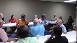
The attendees appointed Gretchen to take notes. Here are her notes, followed by the videos.
Accessibility is not about access, it’s about geographic location…. That was done by one of our appraisers on staff. —Chief Appraiser Silas Hrobar
Rural and commercial land owners got surprises in the mail in July when they received the updated assessments of their properties. Lowndes County Assessors engaged a contractor last year to help with the reassessments of approximately 10,000 properties. Rural properties were categorized as small (under 20 acres) and large (over 20 acres) but complaints were the same, inconsistent and confusing application of criteria.
On Tuesday evening, Farm Bureau hosted an open meeting with Chief Appraiser Silas Hrobar and Tax Assessor Mike Hill (all the assessors were invited but apparently the County Attorney Walter Elliot said that two made a quorum so only one of them could go, even though Senator Ellis Black pointed out that they weren’t actually conducting any business) to discuss the perceived problems.
Tax Assessor Mike Hill said that paving roads drives development.
After having to move to a larger room due to twice as many people as expected, the meeting began with Assessor Hill explaining how evaluations are done in subdivisions, using examples about comparing houses.
Those gathered weren’t interested in subdivisions or house values, they are farmers and larger land owners who saw their raw land property assessments increase by 100-400%. Hill acknowledged that his agenda was different from theirs.
At one point Hrobar noted that his working life wasn’t large rural tracts. A landowner pointed out that for most in the room their life is large rural tracts.
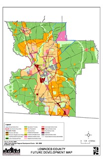
Appraiser Hrobar distributed the criteria used for both small and large tracts, the comparable sales and other factors considered in the re-evaluation. Mike Hill said that paving roads drives development. Silas Hrobar said that staff worked with the consultants to define areas of similarities but didn’t address what those area were or how the areas were determined. One of the criteria on in the packet was wetlands and flooding, yet on the map distributed the Withlacoochee River in North Central Lowndes isn’t even visible and it floods regularly.
Hrobar did say that even though “road frontage” was mentioned five times on a page about “Accessibility Delineations” that accessibility didn’t really mean proximity to roads and road frontage only applied after staff decided on geographical areas of similarity. He confirmed that it was staff and not the consultant who made such decisions.
Regarding why land on both sides of Cat Creek Road at the north end of the county was valued lower than land on Hambrick Road, he had no explanation, nor did Hill.
Regarding why rivers, swamps, and even a paper mill weren’t mentioned at all in the revaluation criteria, Hill and Hrobar kept insisting that the entire county had to be treated uniformly, as a single “subdivision”.
Asked why the Comprehensive Plan wasn’t taken into account, Hill seemed offended, and insisted that the whole county had to be treated uniformly according to market value. He did say there was a way to indicate agricultural use, which was conservation use designation. Hrobar proceeded to explain that at some length. Yet when asked why highest valuation was placed on areas with much land in conservation use, he said that was due to areas of similarity.
Asked why several tracts purchased by Bill Gates east of Lake Park on main roads did not have the highest valuation, Hill and Hrobar’s only answer was that those tracts weren’t in an accessible area, by which they apparently meant an area picked by staff as favored for high valuation.
Questions were raised as to why the “highest value” lands were in the north part of the county especially when US41S is four lanes from Valdosta to Lake Park and there are many large tracts there, including one used as a benchmark. Jerry Arnold pointed out that assessed per acre values on his unpaved road varied widely and he wondered why. Both Hill and Hrobar said that any questions would have to be answered on a per landholder basis at the Tax Assessor Office.
Despite multiple landowners pointing out that the problems were “with the system” or “general”, Hill and Hrobar kept insisting that each landowner had to file an individual appeal.
County Chairman Bill Slaughter remarked that the county had to have revenue to operate on its budget, and if not enough people agreed on the evaluations in time, the county might have to use the previous year’s evaluations. He also acknowledged that he thus had incentive to find a solution to these problems.
Tax Commissioner Felicia Williams had a few comments about how taxes were computed from millage and appraisals. Landowners mentioned several times that she and her office had had nothing to do with the rural land revaluation, which was entirely done by the Tax Appraisers’ office.
Most in attendance hold their land in conservation use which has a prescribed tax value by the State of Georgia and increases at a rate of 3% per year so they didn’t actually see a proposed increase in taxes but should the conservation use be breached they could be responsible for thousands of dollars of taxes given these new assessments.
Yet if their neighbors’ land is not in conservation use, higher valuation adds incentives for the neighbors to sell or subdivide, which in turn puts pressure on the landowners with conservation use as they become surrounded by developed property. Hill and Hrobar had no rebuttal to this point.
Both Hill and Hrobar encouraged any property holder with a question about assessment to contact the assessors office for clarification and to file an appeal with the Board of Equalization. The deadline to file an appeal is August 10, 2015.
Both Black and Hill said they had previously served on the Board of Equalization. When asked whether the BoE could address the systemic and general issues raised, they said no: only specific parcels.
When someone suggested an appeal beyond the BoE might be necessary, Hill sarcastically wished everyone luck with that.
The only apparent route to fixing these general problems seems to be through the Tax Assessors next year, yet the only Tax Assessors present expressed little interest in doing so, and the only staff present kept reiterating that each landowner had to deal with their own case separately.
In any case, the first step is to appeal by the August 10, 2015 deadline.
 Who’s Who:
Lowndes County Tax Assessors: W.G. Walker, Mike Hill, and Leroy Butler Jr., and staff: Silas Hrobar, Chief Appraiser.
The
Board of Equalization.
Who’s Who:
Lowndes County Tax Assessors: W.G. Walker, Mike Hill, and Leroy Butler Jr., and staff: Silas Hrobar, Chief Appraiser.
The
Board of Equalization.
Compare: the Comprehensive Plan to this revaluation here (PDF). Are Bill Gates and subdivisions really more important than agriculture or rivers or public transportation?
Sprawl: Is that what we want? sprawling residential growth is a certain ticket to fiscal ruin (Or at least big tax increases). PDF of the report by UGA Prof. Jeffrey H. Dorfman Lowndes County paid for in 2007, The Local Government Fiscal Impacts of Land Use in Lowndes County.
Here’s a video playlist:
Videos: Rural revaluation meeting at Farm Bureau 2015-08-04
Video by Gretchen Quarterman for Lowndes Area Knowledge Exchange (LAKE),
Valdosta, Lowndes County, Georgia.
-jsq
Short Link: