Received yesterday on Florida sinkholes spreading real estate effects in same Aquifer as under Lowndes County. -jsq
John — Thank you for pressing forward on this important issue for the airmen and their families at Moody AFB as well as for all citizens of Lowndes County. My colleagues and I are also concerned and hope that we can eventually obtain the Phase I geotechnical study. Of course, we have our own research agendas as well as a desire to see our students working on these problems close to their own university campus. In particular, one of my undergraduate students just completed his thesis on karst subsidence beneath a house in Lowndes County. Here is a link to a poster where he presented those finding to our undergraduate research conference: GPR Investigation of Subsidence.
-Don Thieme
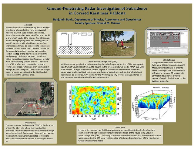
Ground-Penetrating Radar Investigation of Subsidence
Benjamin Davis, Department of Physics, Astronomy, and Geosciences
in Covered Karst near Valdosta
Faculty Sponsor: Donald M. ThiemeAbstract
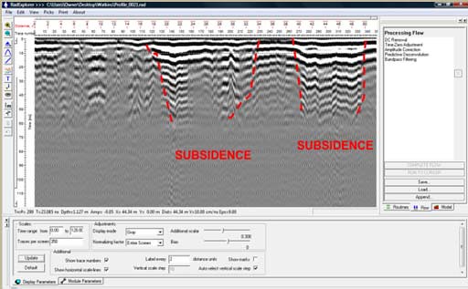
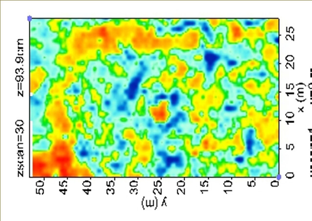
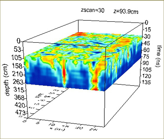
We employed Ground-Penetrating Radar (GPR) to investigate a house lot in a rural area west of valdosta at which subsidence had occurred. subsurface anomalies were identined in a 29 x 51 m grid which abutted the house. Two other areas on the same property were also investigated to identify locations which had fewer subsurface anomalies and might be less prone to subsidence than the current house site. The land surface on the property is variably mantled by indurated sand at the top ofthe Hawthorne Group in the local geology. soil auger samples taken from within the grid correspond to differences in radar wave velucity along specinc profiles. The entire grid of 29 profiles was combined to prepare ”Time Slice” maps, which can then be imaged in a single 3D block diagram. Time-Slice GPR analysis shows promise for estimating the likelihood of subsidence in the Valdosta area.
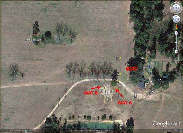
Watkins site
The area north of the house site (WAT) is the location of the 29 x 51 m grid where this investigation identified subsidence related to the structural damage to the house itself. Two areas to the south and west of the original house were investigated as locations which the owner was interested in moving his house to.
Ground-Penetrating Radar [GPR)
GPR is an active geophysical technique using the radio frequency portion of Electromagnetic spectrum at wavelengths from 0.3 to 3000m. In the present study we used a MALA 100 MHz GPR system. Changes in sediment type or degree of compaction are recorded when the radar wave is reflected back to the antenna. Areas of subsidence such as sinkholes in karst regions can be identified. GPR results for the Watkins property provide strong evidence for the subsidence which already affected the house site.
GPR Software
GPR profiles were collected in the field using RAMAC Groundvision GPR Measurement software in order to make 1D images. we used GPR-Slice software to turn our 2D images into 3D models to generate a visible degree of depth of subsidence on the Watkins property.
Conclusion
In conclusion, we ran two field investigations where we identified multiple subsurface anomalies trending beneath and around the foundation of the house using Ground-Penetrating Radar (GPR). Following our fieldwork we determined that the two new lots that were scanned using GPR were resting on top of indurated sand and clay of the Hawthorne Group which is more stable.
Short Link: