 The VDT and the Commission’s district maps don’t agree,
and the Board of Elections doesn’t know.
David Rodock writes in the VDT today that
County revives expanding Lowndes commission:
The VDT and the Commission’s district maps don’t agree,
and the Board of Elections doesn’t know.
David Rodock writes in the VDT today that
County revives expanding Lowndes commission:
During a special meeting Monday, county commissioners unanimously approved a resolution to include two additional voting districts within Lowndes County.Last year, this expansion failed in the legislature on a technicality. If the Commission and staff don’t make the same mistake, it seems likely the legislature will approve these new districts.The two proposed voting districts would allow for greater representation at County Commission meetings by allowing for an expansion of the current available voting representatives from three to five, while keeping a non-voting commission chairman.
But the district map
the VDT published (see above)
is not the same
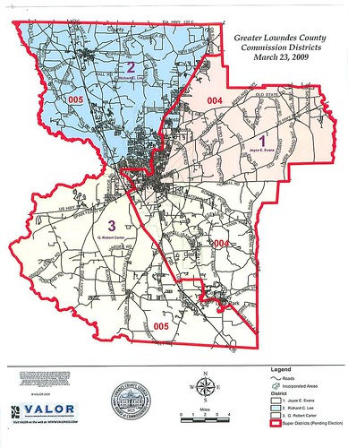 as the district map
on the County Commission’s own web pages,
which is dated “March 23, 2009”.
Neither are the same as the map the VDT published
February 26, 2009.
as the district map
on the County Commission’s own web pages,
which is dated “March 23, 2009”.
Neither are the same as the map the VDT published
February 26, 2009.
Which map is correct? The voters might like to know who they can vote for in these new districts. Are people on Old Pine Road or in Dasher in the District 4 (east) or District 5 (west)? What about Orr Road and Lake Park?
So I called the Lowndes County Board of Elections and asked Supervisor of Elections Deb Cox which map was correct. She answered,
“I don’t have a clue! They technically don’t have to tell us until they’re doing the redistricting. We’re actually a state entity, not a county entity.”She added,
“Some other organizations do let us know, such as Valdosta, Hahira, and the two school boards, and that’s welcome.”I wondered how she would find out, and she said,
“I’ll ask the county for a current map, or maybe RDC.”
Maybe the Lowndes County Commission could do with some more transparency.
-jsq
Short Link: