Tag Archives: USGS

Lowndes County continuing funding for USGS HWY 122 Stream Gauge —Ashley Tye @ LCC 2012-09-10

Lowndes County Emergency Management Director Ashley Tye reported to the Lowndes County Commission at their Work Session yesterday morning that 
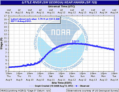
after the floods of 2009, Lowndes County negotiated with USGS to put a stream level monitor on the Withlacoochee Little River at the GA 122 bridge, and the county typically renews that funding once a year. We shall see whether they approve that this evening.

Here's the video:

Lowndes County continuing funding for USGS HWY 122 Stream Gauge —Ashley Tye
Work Session, Lowndes County Commission (LCC),
Video by Gretchen Quarterman for Lowndes Area Knowledge Exchange (LAKE), Valdosta, Lowndes County, Georgia, 10 September 2012.

-jsq

Open Records Officer at Lowndes County Commission @ LCC 2012-09-10

Apparently the Lowndes County Commission has noticed the new provisions of the Georgia Open Records and Open Meetings laws that VLCIA’s lawyer explained to the Industrial Authority back in May, seeing these two items on the agenda for Monday morning and Tuesday evening:

5.a. Adopt Resolution Appointing an Open Records Officer
5.b. Resolution Regarding Review & Approval of Minutes of Executive Sessions

Plus infrastructure for two subdivsisions, one of them the famous Glen Laurel, several well/septic rezonings, approval of USGS Funding Agreement for HWY 122 Stream Gauge (one of the four that let us know about river flooding in Lowndes County less than a month ago), a beer license, and approval of the changes to the ULDC that were discussed in the recent Planning Commission meeting, in the public hearing the public didn’t know about. And more.

Here’s the agenda.

LOWNDES COUNTY BOARD OF COMMISSIONERS
PROPOSED AGENDA
WORK SESSION, MONDAY, SEPTEMBER 10, 2012, 8:30 a.m.
REGULAR SESSION, TUESDAY, SEPTEMBER 11, 2012, 5:30 p.m.
327 N. Ashley Street – 2nd Floor
Continue reading