Many of the same factors that cause the prolonged extreme drought we’ve been having (deforestation, impervious surfaces, climate change) also produce flooding when we get a little rain. The flooding map by NWS Advanced Hydrologic Prediction Service, Weather Forecast Office Tallahassee, FL, 2012-08-14 shows minor flooding on the Withlacoochee River at Skipper Bridge Road.
WTXL yesterday posted PR from Lowndes County, Georgia, Withlacoochee River under watch due to rising water, flood warnings,
 LOWNDES COUNTY, Ga.—Due to rising waters and the issuance of a Flood Warning by the National Weather Service, Lowndes County Emergency Management continues to monitor rising water levels on the Withlacoochee River at the Skipper Bridge Road stream gauge site.
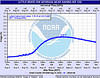
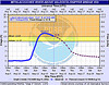
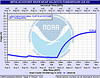
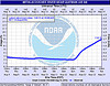
Currently, the water level stands at approximately 14.3 feet and is expected to crest this afternoon at approximately 14.5 feet.
While a flood warning is in effect, the only area flooded at these 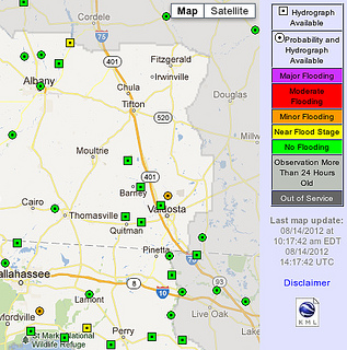 levels are woodland areas near the river. Historically, flooding does not affect local roads and/or residences until water levels reach approximately 17 feet.
Lowndes County Emergency Management will continue to monitor conditions and additional updates will be distributed as new information becomes available. While there is no cause for immediate concern, citizens are encouraged to remain aware of their surroundings.
Residents may monitor local river levels by accessing real time stream gauge information by visiting the following link: water.weather.gov/ahps2/index.php?wfo=tae.
For more information, please contact Lowndes County Public Information Officer, Paige Dukes, 229-292-6142 or pdukes@lowndescounty.com.
Curiously, on the County’s own Press Releases web page, there’s no mention of this PR.
-jsq