 Since we posted the
Reapportionment maps
obtained Tuesday evening,
the county has posted PDF versions
of this same information on their own website.
Copies are
on the LAKE website and appended
below.
I’ve added HTML tables of the statistics.
Since we posted the
Reapportionment maps
obtained Tuesday evening,
the county has posted PDF versions
of this same information on their own website.
Copies are
on the LAKE website and appended
below.
I’ve added HTML tables of the statistics.
VAP is Voting-Age Population.
-jsq
Commission Explansion Update
At the December 13, 2011, meeting of the Lowndes County Board of Commissioners, Commissioners adopted a required resolution to transmit the plan for outlining apportionment for Lowndes County Commission Districts 1, 2, 3 and the newly created 4 & 5. During the next week, the resolution, plans and maps will be forwarded to a member of Lowndes County’s local legislative delegation for submission to the Georgia General Assembly, during the upcoming session. Once approved by the General Assembly and signed by the Governor, the appropriate information will be forwarded to the Department of Justice for approval. Once approved by the Department of Justice, Lowndes County can move forward with the districts for the 2012 elections. Please note that while the maps listed below have been formulated by the Board of Commissioners in conjunction with assistance from the Office of Reapportionment, the General Assembly and/or the Department of Justice could reject them. These maps are being published as the most recent information available only. For questions or more information, please contact County Clerk, Paige Dukes, 229-671-2400 or pdukes@lowndescounty.com. Additional information regarding this matter will be updated at this location, as it becomes available. Thank you for your interest in Lowndes County government.- Lowndes County Proposed Commission Districts 1, 2, & 3 Map
-
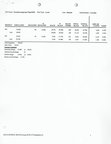
Summary Statistics for Proposed Commission Districts 1, 2, & 3
Plan Name: lowndesccp1-2011 Plan Type : Local User: Shantee Administrator: LowndesDISTRICT POP. DEVIATION BLACK BLACK COMBO TOTAL BLACK HISP. OR LATINO HISP% 001 36,536 125 0.34% 23,507 64.34% 474 23,981 65.64% 1,639 4.49% VAP 26,461 16,187 61.17% 214 16,401 61.98% 1,123 4.24% 002 36,829 418 1.15% 6,909 18.76% 396 7,305 19.83% 1,598 4.34% VAP 27,292 4,942 18.11% 148 5,090 18.65% 1,007 3.69% 003 35,868 -543 -1,49% 8,726 24.33% 278 9,004 25.10% 2,001 5.58% VAP 28,510 6,788 23.81% 117 6,905 24.22% 1,337 6.69% Total Population: 109,233 Ideal Value: 36,411 Summary Statistics Population Range: 35,868 to 36,829 Absolute Overall Range: 961 Relative Range: -1.49% to 1.15% Relative Overall Range: 2.64% DATA SOURCE: 2010 US Census PL94-171 Population Co
- Lowndes County Proposed Commission Districts 4 & 5 Map
-
Summary Statistics for Proposed Commission Districts 4 & 5
Plan Name: lowndesccsupprop1-Tiger2010 Plan Type : Local User: Shantee Administrator: LowndesDISTRICT POP. DEVIATION BLACK BLACK COMBO TOTAL BLACK HISP. OR LATINO HISP% 004 54,588 -28 -0.05% 29,761 54.52% 695 30,456 55.79% 2,483 4.55% VAP 40,065 20,838 52.01% 281 21,119 52.71% 1,687 4.21% 005 54,645 29 0.05% 9,381 17.17% 453 9,834 18.00% 2,755 5.04% VAP 42,198 7,079 16.78% 198 7,277 17.24% 1,780 4.22% Total Population: 109,233 Ideal Value: 54,616 Summary Statistics Population Range: 54,588 to 54,645 Absolute Overall Range: 57 Relative Range: -0.05% to 0.05% Relative Overall Range: 0.10% DATA SOURCE: 2010 US Census PL94-171 Population Co
Short Link: