

LAKE: Rural Land Revaluation, Tax Assessors, 2015-07-14 [Up]
There is no resemblance between the Tax Assessors' Rural Land Accessibility Codes and the Greater Lowndes 2030 Comprehensive Plan Community Agenda's Future Development Map. The Comprehensive Plan shows no future development outside the orange area, and recommends keeping development within the red line of existing water and sewer service. The Tax Assessors' map takes none of that into account, and staff confirmed neither were considered. This rural land revaluation thus becomes a vehicle to drive development straight north into the agricultural areas of the county, not even stopping at the Withlacoochee River. That way lies sprawl, which as Dr. Jeffrey H. Dorfman of UGA has said,
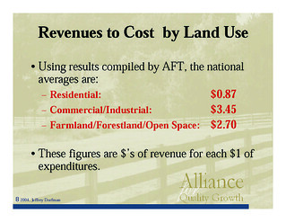
Here is Dr. Dorfman's 2007 report that the county paid for, The Local Government Fiscal Impacts of Land Use in Lowndes County: Revenue and Expenditure Streams by Land Use Category.
All three of those Bill Gates sales “were used in the market analysis of large rural land tracts”. Two of them were benchmark sales which were instrumental in arriving at the base land schedule for large tracts”. So not only does this rural land revaluation drive development towards agricultural land: it does so for the benefit of landowners from other states.
However, none of the rivers or creeks were taken into account. The Withlacoochee River does not even appear on the maps, except by inference as part of the west border of the county, and similarly for the Little River and the Alapaha River on the east. The soil map does consider wetlands and wetland soil types, and the sales land breakdown does include categories for "pond" and "swamp/Wetland". But there's no mention of the rivers or their watersheds, even though the Comprehensive Plan explicitly considers those. Also, although supposedly:
I have not yet talked to a property owner who was contacted by the Tax Assessors' office about this revaluation, and cursory inspection revealed trees planted seven years ago weren't known to the Tax Assessors. Many acres planted in the Conservation Reserve Program (CRP), for example, don't yet show up in county aerial maps.
The need to conserve agriculture is the flip side of the county's need for public transportation. Bus routes or other public transit would draw development towards those public transit corridors, and away from agricultural areas.
Note it was not the Tax Commissioner who did this rural land revaluation. She collects the taxes according to the assessments and the millages determined by local governments including the Lowndes County Commissioners and Lowndes County Board of Education. The Lowndes County Commission did discuss and approve a contract between the Tax Assessors and a third-party contractor for developing the revaluations. But it's the Tax Assessors who set land valuations. Tax Assessor W.G. Walker tells me that, although the Georgia Department of Community Affairs requires a Comprehensive Plan for every county, the Georgia Department of Revenue forbids Tax Assessors from considering that Comprehensive Plan. He said the path to deal with that was first to appeal your assessment. Then when the Assessors respond, take the case to the Board of Equalization (BOE). Walker said the BOE is not bound by the Department of Revenue prohibition on looking at the Comprehensive Plan. I specifically asked him if the BOE could consider not just a single property, but also larger issues such as the need to preserve agricultural areas as recommended by the Comprehensive Plan. He said yes.
The list on lowndescounty.com of Lowndes County's elected Tax Assessors is not even correct: Doyle Kelly is no longer serving due to illness. The Tax Assessors' own website lists only two members: W.G. Walker and Mike Hill. After some research, it turns out the new third Assessor, appointed by the governor in May, is Rev. Leroy Butler, Jr. None of them appear to have any agricultural experience. The lowndescounty.com list of the Board of Equalization also is not correct, and there seems to be no other public website list of its members. I called Beth C. Greene, Clerk of Superior Court, and asked her for the real list of Board of Equalization members, which is:
Beth Greene said reappointments will come up again with the next Grand Jury, September 2015 (they have two a year: in March and in September). She also said she would contact the County Clerk and see if the list on lowndescounty.com could be fixed. A commenter when candidates were being sought remarked that among the BOE's options was:
That appears to be what we need for the whole county. Many rural landowners were no doubt surprised to find their valuations almost or more than doubled, but that's not the main issue. The main issue is this revaluation ignored the Comprehensive Plan and any need to conserve agricultural land. If we wanted to live in Atlanta, we would. Not everyone wants every tree chopped down or every acre paved over in Lowndes County. -jsq
Greater Lowndes 2030 Comprehensive PlanDocumentLand Sales DetailBreakdown 1-4Breakdown 5-8Breakdown 8-10Large TractsLarge AcreageMaps: Tract AccessibilityProcedures ExtendedAbsorption and sizeStudies and CalculationsAddendum BaseMaps: Sales, all Lowndes CountyMaps: Quarterman RoadTax Assessors |
 Lowndes Area Knowledge Exchange by LAKE is licensed under a Creative Commons Attribution-Share Alike 3.0 United States License.
Privacy Policy
Lowndes Area Knowledge Exchange by LAKE is licensed under a Creative Commons Attribution-Share Alike 3.0 United States License.
Privacy Policy
 Blog
Blog YouTube
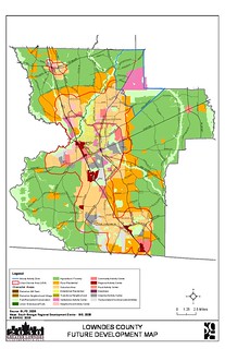


![[Lowndes County Future Development Map]](small/future-development.jpg)
![[Lowndes Co Rural Land Revaluation (Large Tracts)]](small/SCAN1581.jpg)
![[Benchmark sales in yellow]](small/SCAN1583.jpg)
![[Lakeland Sands LLC]](small/SCAN1579.jpg)
![[DWS Enterprises LLP]](small/SCAN1580.jpg)
![[Timber Type]](small/SCAN1584.jpg)
![[Land breakdown (1 of 10)]](small/SCAN1585.jpg)
![[Land breakdown (2 of 10)]](small/SCAN1586.jpg)
![[Land breakdown (3 of 10)]](small/SCAN1587.jpg)
![[Land breakdown (4 of 10)]](small/SCAN1588.jpg)
![[Land breakdown (5 of 10)]](small/SCAN1589.jpg)
![[Land breakdown (6 of 10)]](small/SCAN1590.jpg)
![[Land breakdown (7 of 10)]](small/SCAN1591.jpg)
![[Land breakdown (8 of 10)]](small/SCAN1592.jpg)
![[Land breakdown (9 of 10)]](small/SCAN1593.jpg)
![[Land breakdown (10 of 10)]](small/SCAN1594.jpg)
![[Base Land Schedule for Large Tracts]](small/SCAN1595.jpg)
![[Land use and productivity ratings]](small/SCAN1596.jpg)
![[Acre break rationale]](small/SCAN1597.jpg)
![[Acre break graph]](small/SCAN1598.jpg)
![[Accessibility Delineations]](small/SCAN1599.jpg)
![[Large Tract Sales]](small/SCAN1600.jpg)
![[Rural Land Accessibility Codes (yellow, blue, green)]](small/yellow-map.jpg)
![[Procedures used in creating the delineations]](small/SCAN1602.jpg)
![[Extending factors throughout the entire grid]](small/SCAN1603.jpg)
![[Absorption factor calculation]](small/SCAN1604.jpg)
![[Accessibility/Size Table for Large Tracts]](small/SCAN1605.jpg)
![[Accessibility/Size Factors]](small/SCAN1606.jpg)
![[Large Tract Sales/Assessment Ratio Studies (what were the outliers?)]](small/SCAN1607.jpg)
![[Large Tract calculations]](small/SCAN1608.jpg)
![[Summary]](small/SCAN1609.jpg)
![[Addendum -- Establishing Base Values]](small/SCAN1610.jpg)
![[The productivity indexes are tweaked]](small/SCAN1611.jpg)
![[Small Tracts]](small/small-crop.jpg)
![[Large Tracts]](small/large-crop.jpg)
![[Aerial]](small/SCAN1577.jpg)
![[Topo]](small/SCAN1578.jpg)
![[W.G. Walker]](small/walker-crop.jpg)
![[Mike Hill]](small/mike-hill.jpg)
![[Leroy Butler Jr.]](small/leroy-butler.jpg)