LAKE: WWALS Southwings flight over Union & Bradford Co. FL Phosphate Mine Site [Up]
Here are aerials of the land the Union County, Florida, Commissioners will be
voting on in their Comprehensive Plan, 4:30-9PM, Monday, 17 September 2017,
at Union County High School, 1000 S. Lake Avenue, Lake Butler, FL 32054.
![[WNW from Compressor Station up FGT pipeline to Columbia Co., 10:18:14, 29.911420, -82.332408]](small/20170901_101814.jpg)
WNW from Compressor Station up FGT pipeline to Columbia Co., 10:18:14, 29.9114200, -82.3324080
There are two facebook events, by
Citizens Against Phosphate Mining in North Central Florida
and by
Our Santa Fe River.
I took these pictures in Union and Bradford Counties, Florida,
of
the proposed HPS II phosphate mine site,
on a Southwings flight for WWALS Watershed Coalition
1 September 2017.
You can help figure out what some of them show.
The main conclusion, already published in much briefer form by Jim Tatum
with a few pictures he took,
is that
there was no sign of any heavy equipment or any mining.
The pictures here cover the widest area of the overflight,
and can serve as a baseline in case anything does happen.
More pictures will follow.
See also WWALS blog post.
![[Crew: jsq, Carol, Jim, Roy, 09:38:49, 30.0580556, -82.4541667]](small/20170901_093849.jpg)
Crew: jsq, Carol, Jim, Roy, 09:38:49, 30.0580556, -82.4541667
The flight crew was:
- Roy Zimmer, Southwings pilot
- John S. Quarterman, navigator and photographer
- Carol Burton, local guide and pathfinder
- Jim Tatum, photographer and instigator
Thanks to Dr. Steve Pieczenik for a generous contribution to WWALS.
And thanks as always to Southwings and Amanda Wheelock
for making these flights possible.
Where I could figure out what I was looking at, I have labeled
some of these pictures and corrected their coordinates.
You may recognize places better than I did.
If so, click on the small picture to get a bigger picture
with a form where you can enter comments and even a suggested latitude and
longitude.
We will get to your suggestions as quickly as we can.
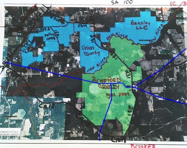
The pictures will make a lot more sense with a map
of the proposed mine site, such as this one, which also has
the Florida Gas Transmission (FGT) pipeline drawn on it:
For localization of the photographs I also used:
![[SW lr Santa Fe River, New River, Tiger Field, 09:50:10, 29.932477, -82.392006]](small/20170901_095010.jpg)
SW lr Santa Fe River, New River, Tiger Field, 09:50:10, 29.9324770, -82.3920060
Some of these pictures from outside the mine site may seem unrelated,
but there are large stretches of Union County owned by mine proponents
that are west of the proposed mine site, but could be used for expansion.
Similarly, there is a large area of Bradford County north of the
proposed site owned by another party that could be used for expansion.
The FGT pipeline runs right through the mine site: what could possibly go wrong?
And the towns, the rivers, and the confluence are some of the things that would be affected
by phosphate mining.
We flew in a zig-zag pattern from north of Worthington Springs, south down
to Flying Tiger Field, east past to the northeast edge of the mine site,
down to the FGT Brooker Compressor Station, south to Brooker,
north to the northwest corner of the mine site in Bradford County,
clockwise up the New River,
back down the New River past Worthington Springs,
and out.
- Northwest of mining site, Union County
- Western corner of mining site, Union County
- Central mining site, Union County
- Hazen and New River Farms mine sites, Bradford County
- Howard mine site, Union County
- New River Properties and Beasley mine sites, Union County, FL
- Weyerhaueser, Union County, FL
- N Bradford County & FGT Pipeline
- SE CR 137, Union County, FL
- Bradford County, FL
- Union County, FL at New River S of FL 100
- Beasley mine site, Union County
- FGT Brooker Compressor Station
- Hazen Mine site, Bradford County, FL
- Brooker, Bradford County, FL
- East side of Hazen mine site
- Southwest corner of Bradford County
- West side of Hazen mine site, Bradford County, FL
- Northwest corner, Hazen mine site, Bradford County, FL
- North side of Hazen mine site at New River
- South to FGT Brooker Compressor Station
- Central Hazen mine site, Bradford County, FL
- More
- Again FGT Brooker Compressor Station
- New River Farms mine site on New River, Bradford County, FL
- Again Hazen mine site, New River, Bradford Co., FL
- Back to Union County
- Back to Bradford County
- Turning back to Union County
- And Bradford County again
- And Union County again
- Once again, Bradford County
-jsq, John S. Quarterman, Suwannee RIVERKEEPER®
You can join this fun and work by becoming a WWALS member today!
PS: Why are these pictures on the LAKE website and not the WWALS website?
Tedious technical reasons.
PPS: Yes, some of them will also be published on facebook.
Crew: jsq, Carol, Jim, Roy, 09:38:49, 30.0580556, -82.4541667
![[South down FL 121 across Worthington Springs to the New River Bridge, 09:42:26, 29.9631545, -82.4134989]](small/20170901_094226.jpg)
South down FL 121 across Worthington Springs to the New River Bridge, 09:42:26, 29.9631545, -82.4134989
![[South across CR 18A to Flying Tiger Field, 09:42:38, 29.9631545, -82.4134989]](small/20170901_094238.jpg)
South across CR 18A to Flying Tiger Field, 09:42:38, 29.9631545, -82.4134989
![[WNW to microwave tower, SW 121st Ave, 09:43:01, 29.9582289, -82.4050337]](small/20170901_094302.jpg)
WNW to microwave tower, SW 121st Ave, 09:43:01, 29.9582289, -82.4050337
![[W across Little Spring Rd. & FL 121 down CR 18, 09:43:12, 29.9582289, -82.4050337]](small/20170901_094312.jpg)
W across Little Spring Rd. & FL 121 down CR 18, 09:43:12, 29.9582289, -82.4050337
![[NW across FL 121 @ SW 50th Tr, 09:43:17, 29.9454194, -82.4099449]](small/20170901_094317.jpg)
NW across FL 121 @ SW 50th Tr, 09:43:17, 29.9454194, -82.4099449
![[NNW across tower on SW 121st Ave: more land owned by miners? 09:43:19, 29.9454194, -82.4099449]](small/20170901_094319.jpg)
NNW across tower on SW 121st Ave: more land owned by miners? 09:43:19, 29.9454194, -82.4099449
![[RR bridge, FL 121, 09:43:26, 29.9450202, -82.4150791]](small/20170901_094326.jpg)
RR bridge, FL 121, 09:43:26, 29.9450202, -82.4150791
![[N across tower on SW 121st Ave., 09:43:28, 29.9451295, -82.4160906]](small/20170901_094328.jpg)
N across tower on SW 121st Ave., 09:43:28, 29.9451295, -82.4160906
![[N from Worthington Springs up FL 121, 09:43:37, 29.9533990, -82.4150795]](small/20170901_094337.jpg)
N from Worthington Springs up FL 121, 09:43:37, 29.9533990, -82.4150795
![[WNW from CR 18 up FGT pipeline past more Prichett Holdings, 09:43:51, 29.9454089, -82.4280951]](small/20170901_094351.jpg)
WNW from CR 18 up FGT pipeline past more Prichett Holdings, 09:43:51, 29.9454089, -82.4280951
![[N to pond on Canova land off SW 121st Ave., 09:43:56, 29.9403131, -82.4218805]](small/20170901_094356.jpg)
N to pond on Canova land off SW 121st Ave., 09:43:56, 29.9403131, -82.4218805
![[N up 11th Lane, 09:44:10, 29.9455614, -82.4391178]](small/20170901_094410.jpg)
N up 11th Lane, 09:44:10, 29.9455614, -82.4391178
![[NE to 10600 SW 54TH RUN, 09:44:34, 29.9530414, -82.4369674]](small/20170901_094434.jpg)
NE to 10600 SW 54TH RUN, 09:44:34, 29.9530414, -82.4369674
![[N up SW 71st St over Williams and Howard land, 09:44:37, 29.9530414, -82.4369674]](small/20170901_094437.jpg)
N up SW 71st St over Williams and Howard land, 09:44:37, 29.9530414, -82.4369674
![[NE across SW 107TH AVE to state-owned swamp lands, 09:44:46, 29.9589204, -82.4510533]](small/20170901_094446.jpg)
NE across SW 107TH AVE to state-owned swamp lands, 09:44:46, 29.9589204, -82.4510533
![[NE across Howard residences on SW 71st St @ SW 70th Path, 09:45:08, 29.9655079, -82.4515447]](small/20170901_094508.jpg)
NE across Howard residences on SW 71st St @ SW 70th Path, 09:45:08, 29.9655079, -82.4515447
![[ENE H&S Land building foreground, 09:45:14, 29.9760145, -82.4524277]](small/20170901_094514.jpg)
ENE H&S Land building foreground, 09:45:14, 29.9760145, -82.4524277
![[Canals on Shadd Properties, SW CR 796, 09:45:19, 29.9760145, -82.4524277]](small/20170901_094519.jpg)
Canals on Shadd Properties, SW CR 796, 09:45:19, 29.9760145, -82.4524277
![[E across Howard pond & Shadd properties W of state swamp, SW CR 796, 09:45:24, 29.981694, -82.446699]](small/20170901_094524.jpg)
E across Howard pond & Shadd properties W of state swamp, SW CR 796, 09:45:24, 29.9816940, -82.4466990
![[SE across Howard pond, SW CR 796, 09:45:28, 29.984713, -82.443651]](small/20170901_094528.jpg)
SE across Howard pond, SW CR 796, 09:45:28, 29.9847130, -82.4436510
![[SE, Shadd pond, cannals, SW CR 796, 09:45:33, 29.984857, -82.442598]](small/20170901_094533.jpg)
SE, Shadd pond, cannals, SW CR 796, 09:45:33, 29.9848570, -82.4425980
![[SE, Shadd and Howard lands S of state swamp, 09:45:34, 29.985160, -82.441077]](small/20170901_094534.jpg)
SE, Shadd and Howard lands S of state swamp, 09:45:34, 29.9851600, -82.4410770
![[S across swamp down Shadd canal, 09:46:02, 29.986652, -82.431069]](small/20170901_094602.jpg)
S across swamp down Shadd canal, 09:46:02, 29.9866520, -82.4310690
![[SSW from swamp: Worthington Springs, New River, Bradford Co., 09:46:14, 29.981989, -82.428819]](small/20170901_094614.jpg)
SSW from swamp: Worthington Springs, New River, Bradford Co., 09:46:14, 29.9819890, -82.4288190
![[SW swamp drainage, 09:46:17, 29.9760145, -82.4524277]](small/20170901_094617.jpg)
SW swamp drainage, 09:46:17, 29.9760145, -82.4524277
![[SW drainage canal, 09:46:30, 29.975909, -82.431509]](small/20170901_094630.jpg)
SW drainage canal, 09:46:30, 29.9759090, -82.4315090
![[SW from swamp: Howard & Williams land, 09:46:30, 29.972204, -82.435852]](small/20170901_094631.jpg)
SW from swamp: Howard & Williams land, 09:46:30, 29.9722040, -82.4358520
![[WSW closeup drainage canal, 09:46:43, 29.974195, -82.428012]](small/20170901_094644.jpg)
WSW closeup drainage canal, 09:46:43, 29.9741950, -82.4280120
![[NW pond in swamp, 09:46:46, 29.980088, -82.426269]](small/20170901_094646.jpg)
NW pond in swamp, 09:46:46, 29.9800880, -82.4262690
![[NW Drain from pond in swamp, 09:46:55, 29.978054, -82.424467]](small/20170901_094655.jpg)
NW Drain from pond in swamp, 09:46:55, 29.9780540, -82.4244670
![[NW 11927 SW 69TH TRAIL, 09:46:57, 29.975786, -82.425166]](small/20170901_094657.jpg)
NW 11927 SW 69TH TRAIL, 09:46:57, 29.9757860, -82.4251660
![[NNW closeup pond in swamp, 09:47:01, 29.979598, -82.426109]](small/20170901_094701.jpg)
NNW closeup pond in swamp, 09:47:01, 29.9795980, -82.4261090
![[N across Shadd, Garmon, state swamplands, 09:47:04, 29.975069, -82.426600]](small/20170901_094704.jpg)
N across Shadd, Garmon, state swamplands, 09:47:04, 29.9750690, -82.4266000
![[NNE up drainage canal, 09:47:19, 29.971787, -82.437133]](small/20170901_094719.jpg)
NNE up drainage canal, 09:47:19, 29.9717870, -82.4371330
![[ENE sinkhole? on drainage canal, 09:47:22, 29.973151, -82.434714]](small/20170901_094722.jpg)
ENE sinkhole? on drainage canal, 09:47:22, 29.9731510, -82.4347140
![[S from FL 121 @ CR 239A across Pritchett lands to Tiger Field, 09:48:30, 29.970962, -82.407325]](small/20170901_094830.jpg)
S from FL 121 @ CR 239A across Pritchett lands to Tiger Field, 09:48:30, 29.9709620, -82.4073250
![[S from CR 239A closeup Pritchett mining site E of FL 121, 09:48:33, 29.965201, -82.407163]](small/20170901_094833.jpg)
S from CR 239A closeup Pritchett mining site E of FL 121, 09:48:33, 29.9652010, -82.4071630
![[SW across mine site & FL 121 to Clyatt Well Drilling 09:49:11, 29.962370, -82.410011]](small/20170901_094911.jpg)
SW across mine site & FL 121 to Clyatt Well Drilling 09:49:11, 29.9623700, -82.4100110
![[W across mine site, FL 121, MW tower, 09:49:14, 29.961336, -82.401632]](small/20170901_094914.jpg)
W across mine site, FL 121, MW tower, 09:49:14, 29.9613360, -82.4016320
![[SW from SW 52nd St @ SW 131st Ln across mine site, Worthington Springs, New River, 09:49:16, 29.953815, -82.403490]](small/20170901_094916.jpg)
SW from SW 52nd St @ SW 131st Ln across mine site, Worthington Springs, New River, 09:49:16, 29.9538150, -82.4034900
![[SSW mine site, FGT pipeline, Tiger Field, New River, 09:49:17, 29.950630, -82.402205]](small/20170901_094917.jpg)
SSW mine site, FGT pipeline, Tiger Field, New River, 09:49:17, 29.9506300, -82.4022050
SW lr Santa Fe River, New River, Tiger Field, 09:50:10, 29.9324770, -82.3920060
![[W lr New River Confluence, Tiger Field, FGT pipeline, CR 18A, mine site, 09:50:16, 29.9476083, -82.3951086]](small/20170901_095016.jpg)
W lr New River Confluence, Tiger Field, FGT pipeline, CR 18A, mine site, 09:50:16, 29.9476083, -82.3951086
![[WNW Tiger Field, FGT pipeline into distance, 09:50:19, 29.935562, -82.393925]](small/20170901_095019.jpg)
WNW Tiger Field, FGT pipeline into distance, 09:50:19, 29.9355620, -82.3939250
![[WNW FGT pipeline, MW tower SW 134th Ln, CR 18A, mine site, 09:50:24, 29.937200, -82.394157]](small/20170901_095024.jpg)
WNW FGT pipeline, MW tower SW 134th Ln, CR 18A, mine site, 09:50:24, 29.9372000, -82.3941570
![[N MW tower SW 134th Ln, mine site top center, 09:50:32, 29.936254, -82.396903]](small/20170901_095032.jpg)
N MW tower SW 134th Ln, mine site top center, 09:50:32, 29.9362540, -82.3969030
![[NE from SW 43rd Tr 7 miles to Butler Lake, 09:51:06, 29.9393289, -82.3894308]](small/20170901_095106.jpg)
NE from SW 43rd Tr 7 miles to Butler Lake, 09:51:06, 29.9393289, -82.3894308
![[S from SW 150th Ave @ CR 231A across Howard mine site, New River, mine site Bradford Co., 09:51:59, 29.9723641, -82.3733522]](small/20170901_095159.jpg)
S from SW 150th Ave @ CR 231A across Howard mine site, New River, mine site Bradford Co., 09:51:59, 29.9723641, -82.3733522
![[S from CR 231A to cutout on Duke Road, Five Mile Creek in mine site, red barn 5600 SW CR 18-A, 09:52:02, 29.9723131, -82.3715122]](small/20170901_095202.jpg)
S from CR 231A to cutout on Duke Road, Five Mile Creek in mine site, red barn 5600 SW CR 18-A, 09:52:02, 29.9723131, -82.3715122
![[S 6124 SW 150th Blvd, 09:52:09, 29.9723532, -82.3671365]](small/20170901_095209.jpg)
S 6124 SW 150th Blvd, 09:52:09, 29.9723532, -82.3671365
![[S 5863 150TH LN, 09:52:11, 29.9723532, -82.3671365]](small/20170901_095211.jpg)
S 5863 150TH LN, 09:52:11, 29.9723532, -82.3671365
![[S Scouthole, S CR 231, 09:52:16, 29.9716497, -82.3630448]](small/20170901_095216.jpg)
S Scouthole, S CR 231, 09:52:16, 29.9716497, -82.3630448
![[SSW Scouthole to mine site W of Duke Road, 09:52:18, 29.9711537, -82.3614372]](small/20170901_095218.jpg)
SSW Scouthole to mine site W of Duke Road, 09:52:18, 29.9711537, -82.3614372
![[S Hazen mine site N tip between New River and CR 231, 09:53:15, 29.946484, -82.342382]](small/20170901_095315.jpg)
S Hazen mine site N tip between New River and CR 231, 09:53:15, 29.9464840, -82.3423820
![[S CR 231 mine site: Hazen top, New River Farms bottom, 20170901_095316, 09:53:16, 29.948082, -82.340978]](small/20170901_095316.jpg)
S CR 231 mine site: Hazen top, New River Farms bottom, 20170901_095316, 09:53:16, 29.9480820, -82.3409780
![[S from New River across New River Farms mine site, CR 231, Hazen mine site, 09:53:18, 29.945606, -82.332286]](small/20170901_095318.jpg)
S from New River across New River Farms mine site, CR 231, Hazen mine site, 09:53:18, 29.9456060, -82.3322860
![[20170901_095327, 09:53:27, 29.9711537, -82.3614372]](small/20170901_095327.jpg)
20170901_095327, 09:53:27, 29.9711537, -82.3614372
![[W mine sites: New River Farms, CR 231, Hazen, 09:53:28, 29.947371, -82.340137]](small/20170901_095328.jpg)
W mine sites: New River Farms, CR 231, Hazen, 09:53:28, 29.9473710, -82.3401370
![[W lr New River, Hazen, CR 231, New River Farms mine sites, 09:53:35, 29.949573, -82.343273]](small/20170901_095335.jpg)
W lr New River, Hazen, CR 231, New River Farms mine sites, 09:53:35, 29.9495730, -82.3432730
![[W from New River across Howard mine site, Five Mile Creek, SW 48th Path, CR 18A, Flying Tiger Field upper left, 09:53:40, 29.946217, -82.347775]](small/20170901_095340.jpg)
W from New River across Howard mine site, Five Mile Creek, SW 48th Path, CR 18A, Flying Tiger Field upper left, 09:53:40, 29.9462170, -82.3477750
![[W across Howard mine site, 09:53:53, 29.947243, -82.354822]](small/20170901_095353.jpg)
W across Howard mine site, 09:53:53, 29.9472430, -82.3548220
![[W across Howard mine site, Five Mile Creek, SW 48th Path, CR 18A, Pritchett mine site, Worthington Springs, 09:53:54, 29.94613, -82.35657]](small/20170901_095354.jpg)
W across Howard mine site, Five Mile Creek, SW 48th Path, CR 18A, Pritchett mine site, Worthington Springs, 09:53:54, 29.9461300, -82.3565700
![[E down SE 53rd St, CR 231 New River bridge, Howard mine site on right, 09:54:42, 29.952024, -82.349762]](small/20170901_095442.jpg)
E down SE 53rd St, CR 231 New River bridge, Howard mine site on right, 09:54:42, 29.9520240, -82.3497620
![[20170901_095443, 09:54:43, 29.9711537, -82.3614372]](small/20170901_095443.jpg)
20170901_095443, 09:54:43, 29.9711537, -82.3614372
![[E down SE 54th St, CR 231 New River bridge, Howard mine site on right, 09:54:45, 29.953746, -82.351583]](small/20170901_095445.jpg)
E down SE 54th St, CR 231 New River bridge, Howard mine site on right, 09:54:45, 29.9537460, -82.3515830
![[New River flood plain, 09:54:46, 29.955764, -82.345353]](small/20170901_095446.jpg)
New River flood plain, 09:54:46, 29.9557640, -82.3453530
![[NE up New River, Beasley mine site, SE 65th Terrace, 09:54:47, 29.957535, -82.346466]](small/20170901_095447.jpg)
NE up New River, Beasley mine site, SE 65th Terrace, 09:54:47, 29.9575350, -82.3464660
![[NW New River, 18205 SE 65th Way, New River Prop. mine site, prison, 09:55:19, 29.956084, -82.321936]](small/20170901_095519.jpg)
NW New River, 18205 SE 65th Way, New River Prop. mine site, prison, 09:55:19, 29.9560840, -82.3219360
![[20170901_095520, 09:55:20, 29.9711537, -82.3614372]](small/20170901_095520.jpg)
20170901_095520, 09:55:20, 29.9711537, -82.3614372
![[N from New River across mine site: l. New River P. r. Beasley; left center prison; top left Lake Butler, 09:55:21, 29.955080, -82.318300]](small/20170901_095521.jpg)
N from New River across mine site: l. New River P. r. Beasley; left center prison; top left Lake Butler, 09:55:21, 29.9550800, -82.3183000
![[20170901_095522, 09:55:22, 29.9711537, -82.3614372]](small/20170901_095522.jpg)
20170901_095522, 09:55:22, 29.9711537, -82.3614372
![[N New River, SE 185th Ln, Beasley mine site, 09:55:23, 29.955080, -82.318300]](small/20170901_095523.jpg)
N New River, SE 185th Ln, Beasley mine site, 09:55:23, 29.9550800, -82.3183000
![[N Beasley mine site SW corner, 09:55:24, 29.954084, -82.314293]](small/20170901_095524.jpg)
N Beasley mine site SW corner, 09:55:24, 29.9540840, -82.3142930
![[N Beasley mine site, 09:55:25, 29.954456, -82.313422]](small/20170901_095525.jpg)
N Beasley mine site, 09:55:25, 29.9544560, -82.3134220
![[S New River Prop. mine site, SE 65th Terrace, 09:55:51, 29.969046, -82.332813]](small/20170901_095551.jpg)
S New River Prop. mine site, SE 65th Terrace, 09:55:51, 29.9690460, -82.3328130
![[S New River Prop mine site, 09:56:10, 29.968005, -82.327038]](small/20170901_095610.jpg)
S New River Prop mine site, 09:56:10, 29.9680050, -82.3270380
![[SE Weyerhauser, 09:56:12, 29.987104, -82.310566]](small/20170901_095612.jpg)
SE Weyerhauser, 09:56:12, 29.9871040, -82.3105660
![[SE Weyerhauser, Palatka-Lake Butler State Trail, New River, 09:56:14, 29.993869, -82.314025]](small/20170901_095615.jpg)
SE Weyerhauser, Palatka-Lake Butler State Trail, New River, 09:56:14, 29.9938690, -82.3140250
![[ESE Weyerhaueser to Dogwood Drive, 09:56:18, 29.993869, -82.314025]](small/20170901_095618.jpg)
ESE Weyerhaueser to Dogwood Drive, 09:56:18, 29.9938690, -82.3140250
![[SE across Bradford Co. to Lake Sampson, 09:56:25, 29.9769310, -82.3139693]](small/20170901_095625.jpg)
SE across Bradford Co. to Lake Sampson, 09:56:25, 29.9769310, -82.3139693
![[SE across FGT pipeline, 09:56:56, 29.9757041, -82.2945605]](small/20170901_095656.jpg)
SE across FGT pipeline, 09:56:56, 29.9757041, -82.2945605
![[S New River Baptist Church, FGT pipeline, CR 235, 09:57:11, 29.9728104, -82.2861951]](small/20170901_095711.jpg)
S New River Baptist Church, FGT pipeline, CR 235, 09:57:11, 29.9728104, -82.2861951
![[S W D Andrews Farms, FGT pipeline, CR 235, 09:57:16, 29.9719896, -82.2842150]](small/20170901_095717.jpg)
S W D Andrews Farms, FGT pipeline, CR 235, 09:57:16, 29.9719896, -82.2842150
![[SW CR 235 @ SW 161st St, 20170901_095733, 09:57:33, 29.9673959, -82.2749564]](small/20170901_095733.jpg)
SW CR 235 @ SW 161st St, 20170901_095733, 09:57:33, 29.9673959, -82.2749564
![[SW New River Baptist Church, 09:57:35, 29.9666774, -82.2732692]](small/20170901_095735.jpg)
SW New River Baptist Church, 09:57:35, 29.9666774, -82.2732692
![[SE FGT pipeline & CR 235, 09:57:40, 29.9666774, -82.2732692]](small/20170901_095740.jpg)
SE FGT pipeline & CR 235, 09:57:40, 29.9666774, -82.2732692
![[20170901_095758, 09:57:58, 29.9607652, -82.2615553]](small/20170901_095758.jpg)
20170901_095758, 09:57:58, 29.9607652, -82.2615553
![[20170901_095805, 09:58:05, 29.9588887, -82.2585524]](small/20170901_095805.jpg)
20170901_095805, 09:58:05, 29.9588887, -82.2585524
![[20170901_095811, 09:58:10, 29.9571456, -82.2555198]](small/20170901_095811.jpg)
20170901_095811, 09:58:10, 29.9571456, -82.2555198
![[20170901_095817, 09:58:17, 29.9549023, -82.2514414]](small/20170901_095817.jpg)
20170901_095817, 09:58:17, 29.9549023, -82.2514414
![[N up New River to FL 100, 10:01:37, 29.9553803, -82.2825895]](small/20170901_100137.jpg)
N up New River to FL 100, 10:01:37, 29.9553803, -82.2825895
![[20170901_100138, 10:01:38, 29.9553803, -82.2825895]](small/20170901_100138.jpg)
20170901_100138, 10:01:38, 29.9553803, -82.2825895
![[20170901_100148, 10:01:48, 29.9584802, -82.2870137]](small/20170901_100148.jpg)
20170901_100148, 10:01:48, 29.9584802, -82.2870137
![[N across FLORIDA PEST CONTROL & CHEM CO, 10:01:51, 29.9584802, -82.2870137]](small/20170901_100151.jpg)
N across FLORIDA PEST CONTROL & CHEM CO, 10:01:51, 29.9584802, -82.2870137
![[20170901_100153, 10:01:53, 29.9584802, -82.2870137]](small/20170901_100153.jpg)
20170901_100153, 10:01:53, 29.9584802, -82.2870137
![[20170901_100154, 10:01:54, 29.9607278, -82.2899550]](small/20170901_100154.jpg)
20170901_100154, 10:01:54, 29.9607278, -82.2899550
![[Hendricks, SE 74TH WAY , LAKE BUTLER, 10:01:57, 29.9607278, -82.2899550]](small/20170901_100157.jpg)
Hendricks, SE 74TH WAY , LAKE BUTLER, 10:01:57, 29.9607278, -82.2899550
![[S from New River to Palatka-Lake Butler State Trail, 10:02:39, 29.980442, -82.286509]](small/20170901_100239.jpg)
S from New River to Palatka-Lake Butler State Trail, 10:02:39, 29.9804420, -82.2865090
![[S to Trail through FLORIDA PEST CONTROL & CHEM CO, 10:02:41, 29.980836, -82.285095]](small/20170901_100241.jpg)
S to Trail through FLORIDA PEST CONTROL & CHEM CO, 10:02:41, 29.9808360, -82.2850950
![[SE across New River to FLORIDA PEST CONTROL & CHEM CO S. of FL 100, 20170901_100245, 10:02:45, 29.993189, -82.290179]](small/20170901_100245.jpg)
SE across New River to FLORIDA PEST CONTROL & CHEM CO S. of FL 100, 20170901_100245, 10:02:45, 29.9931890, -82.2901790
![[20170901_100246, 10:02:46, 29.9642747, -82.2934587]](small/20170901_100246.jpg)
20170901_100246, 10:02:46, 29.9642747, -82.2934587
![[Trail across CR 237 & New River, 10:02:48, 29.985058, -82.291987]](small/20170901_100248.jpg)
Trail across CR 237 & New River, 10:02:48, 29.9850580, -82.2919870
![[20170901_100249, 10:02:49, 29.9642747, -82.2934587]](small/20170901_100249.jpg)
20170901_100249, 10:02:49, 29.9642747, -82.2934587
![[20170901_100250, 10:02:50, 29.9642747, -82.2934587]](small/20170901_100250.jpg)
20170901_100250, 10:02:50, 29.9642747, -82.2934587
![[20170901_100251, 10:02:51, 29.9642747, -82.2934587]](small/20170901_100251.jpg)
20170901_100251, 10:02:51, 29.9642747, -82.2934587
![[20170901_100252, 10:02:52, 29.9642747, -82.2934587]](small/20170901_100252.jpg)
20170901_100252, 10:02:52, 29.9642747, -82.2934587
![[20170901_100255, 10:02:55, 29.9642747, -82.2934587]](small/20170901_100255.jpg)
20170901_100255, 10:02:55, 29.9642747, -82.2934587
![[S down New River from CR 237, 10:02:59, 29.987472, -82.291082]](small/20170901_100259.jpg)
S down New River from CR 237, 10:02:59, 29.9874720, -82.2910820
![[20170901_100304, 10:03:04, 29.9642747, -82.2934587]](small/20170901_100304.jpg)
20170901_100304, 10:03:04, 29.9642747, -82.2934587
![[20170901_100318, 10:03:18, 29.9642747, -82.2934587]](small/20170901_100318.jpg)
20170901_100318, 10:03:18, 29.9642747, -82.2934587
![[20170901_100320, 10:03:20, 29.9642747, -82.2934587]](small/20170901_100320.jpg)
20170901_100320, 10:03:20, 29.9642747, -82.2934587
![[20170901_100322, 10:03:22, 29.9642747, -82.2934587]](small/20170901_100322.jpg)
20170901_100322, 10:03:22, 29.9642747, -82.2934587
![[SW down New River to Beasley mine site in upper right, 10:03:25, 29.981309, -82.283292]](small/20170901_100325.jpg)
SW down New River to Beasley mine site in upper right, 10:03:25, 29.9813090, -82.2832920
![[WNW Gilman Building Products, 10:03:27, 29.988727, -82.284358]](small/20170901_100327.jpg)
WNW Gilman Building Products, 10:03:27, 29.9887270, -82.2843580
![[20170901_100353, 10:03:53, 29.9642747, -82.2934587]](small/20170901_100353.jpg)
20170901_100353, 10:03:53, 29.9642747, -82.2934587
![[SW to Beasley mine site in upper left, 10:03:58, 29.986182, -82.285625]](small/20170901_100358.jpg)
SW to Beasley mine site in upper left, 10:03:58, 29.9861820, -82.2856250
![[20170901_100435, 10:04:35, 29.9642747, -82.2934587]](small/20170901_100435.jpg)
20170901_100435, 10:04:35, 29.9642747, -82.2934587
![[20170901_100436, 10:04:35, 29.9642747, -82.2934587]](small/20170901_100436.jpg)
20170901_100436, 10:04:35, 29.9642747, -82.2934587
![[NE up the New River, 10:04:36, 29.973043, -82.293993]](small/20170901_100437.jpg)
NE up the New River, 10:04:36, 29.9730430, -82.2939930
![[20170901_100438, 10:04:38, 29.9642747, -82.2934587]](small/20170901_100438.jpg)
20170901_100438, 10:04:38, 29.9642747, -82.2934587
![[20170901_100441, 10:04:41, 29.9642747, -82.2934587]](small/20170901_100441.jpg)
20170901_100441, 10:04:41, 29.9642747, -82.2934587
![[NNW up SE 191st Lane to Gilman Building Products & Lake Butler, 10:04:43, 29.980715, -82.306024]](small/20170901_100444.jpg)
NNW up SE 191st Lane to Gilman Building Products & Lake Butler, 10:04:43, 29.9807150, -82.3060240
![[NW to prison, 10:04:45, 29.980264, -82.307851]](small/20170901_100445.jpg)
NW to prison, 10:04:45, 29.9802640, -82.3078510
![[20170901_100448, 10:04:48, 29.9642747, -82.2934587]](small/20170901_100448.jpg)
20170901_100448, 10:04:48, 29.9642747, -82.2934587
![[N to N edge of Beasley mine site, SE 67th Terrace, 10:04:49, 29.971135, -82.311124]](small/20170901_100449.jpg)
N to N edge of Beasley mine site, SE 67th Terrace, 10:04:49, 29.9711350, -82.3111240
![[20170901_100452, 10:04:52, 29.9642747, -82.2934587]](small/20170901_100452.jpg)
20170901_100452, 10:04:52, 29.9642747, -82.2934587
![[20170901_100453, 10:04:53, 29.9642747, -82.2934587]](small/20170901_100453.jpg)
20170901_100453, 10:04:53, 29.9642747, -82.2934587
![[20170901_100456, 10:04:56, 29.9642747, -82.2934587]](small/20170901_100456.jpg)
20170901_100456, 10:04:56, 29.9642747, -82.2934587
![[NW to prison, 10:04:58, 29.967494, -82.313842]](small/20170901_100458.jpg)
NW to prison, 10:04:58, 29.9674940, -82.3138420
![[20170901_100613, 10:06:13, 29.9642747, -82.2934587]](small/20170901_100613.jpg)
20170901_100613, 10:06:13, 29.9642747, -82.2934587
![[20170901_100616, 10:06:16, 29.9642747, -82.2934587]](small/20170901_100616.jpg)
20170901_100616, 10:06:16, 29.9642747, -82.2934587
![[20170901_100618, 10:06:18, 29.9642747, -82.2934587]](small/20170901_100618.jpg)
20170901_100618, 10:06:18, 29.9642747, -82.2934587
![[20170901_100752, 10:07:52, 29.9642747, -82.2934587]](small/20170901_100752.jpg)
20170901_100752, 10:07:52, 29.9642747, -82.2934587
![[20170901_100753, 10:07:53, 29.9642747, -82.2934587]](small/20170901_100753.jpg)
20170901_100753, 10:07:53, 29.9642747, -82.2934587
![[20170901_100802, 10:08:02, 29.9642747, -82.2934587]](small/20170901_100802.jpg)
20170901_100802, 10:08:02, 29.9642747, -82.2934587
![[20170901_100803, 10:08:03, 29.9642747, -82.2934587]](small/20170901_100803.jpg)
20170901_100803, 10:08:03, 29.9642747, -82.2934587
![[20170901_100805, 10:08:05, 29.9642747, -82.2934587]](small/20170901_100805.jpg)
20170901_100805, 10:08:05, 29.9642747, -82.2934587
![[20170901_100806, 10:08:06, 29.9642747, -82.2934587]](small/20170901_100806.jpg)
20170901_100806, 10:08:06, 29.9642747, -82.2934587
![[SW down CR 237 & FGT pipeline to Compressor Station, 10:08:09, 29.947323, -82.296090]](small/20170901_100809.jpg)
SW down CR 237 & FGT pipeline to Compressor Station, 10:08:09, 29.9473230, -82.2960900
![[SW to Compressor Station, 10:08:14, 29.933746, -82.308626]](small/20170901_100814.jpg)
SW to Compressor Station, 10:08:14, 29.9337460, -82.3086260
![[20170901_100824, 10:08:24, 29.9642747, -82.2934587]](small/20170901_100824.jpg)
20170901_100824, 10:08:24, 29.9642747, -82.2934587
![[20170901_100827, 10:08:27, 29.9642747, -82.2934587]](small/20170901_100827.jpg)
20170901_100827, 10:08:27, 29.9642747, -82.2934587
![[NNW across Compressor Station, 10:09:30, 29.924232, -82.320259]](small/20170901_100930.jpg)
NNW across Compressor Station, 10:09:30, 29.9242320, -82.3202590
![[20170901_100931, 10:09:31, 29.9642747, -82.2934587]](small/20170901_100931.jpg)
20170901_100931, 10:09:31, 29.9642747, -82.2934587
![[NW across Compressor Station, 10:09:39, 29.921100, -82.322076]](small/20170901_100939.jpg)
NW across Compressor Station, 10:09:39, 29.9211000, -82.3220760
![[Hazen Circle H Ranch, SW 175th St, 10:10:14, 29.910560, -82.340394]](small/20170901_101014.jpg)
Hazen Circle H Ranch, SW 175th St, 10:10:14, 29.9105600, -82.3403940
![[20170901_101019, 10:10:19, 29.9642747, -82.2934587]](small/20170901_101019.jpg)
20170901_101019, 10:10:19, 29.9642747, -82.2934587
![[20170901_101022, 10:10:22, 29.9642747, -82.2934587]](small/20170901_101022.jpg)
20170901_101022, 10:10:22, 29.9642747, -82.2934587
![[SSW across SW 163 Ave, Braggs Branch, 10:10:57, 29.888274, -82.317650]](small/20170901_101057.jpg)
SSW across SW 163 Ave, Braggs Branch, 10:10:57, 29.8882740, -82.3176500
![[20170901_101059, 10:10:59, 29.9642747, -82.2934587]](small/20170901_101059.jpg)
20170901_101059, 10:10:59, 29.9642747, -82.2934587
![[20170901_101102, 10:11:02, 29.9642747, -82.2934587]](small/20170901_101102.jpg)
20170901_101102, 10:11:02, 29.9642747, -82.2934587
![[SSW across SW 162 Ave, Braggs Branch, to Santa Fe River, 10:11:03, 29.890248, -82.313606]](small/20170901_101104.jpg)
SSW across SW 162 Ave, Braggs Branch, to Santa Fe River, 10:11:03, 29.8902480, -82.3136060
![[W across Brooker Elementary to mine site top right, 10:11:05, 29.892175, -82.314029]](small/20170901_101105.jpg)
W across Brooker Elementary to mine site top right, 10:11:05, 29.8921750, -82.3140290
![[20170901_101106, 10:11:06, 29.9642747, -82.2934587]](small/20170901_101106.jpg)
20170901_101106, 10:11:06, 29.9642747, -82.2934587
![[20170901_101111, 10:11:11, 29.9642747, -82.2934587]](small/20170901_101111.jpg)
20170901_101111, 10:11:11, 29.9642747, -82.2934587
![[N up FL 231 past Compressor Station, Hazen mine site on left, 10:12:33, 29.901059, -82.331196]](small/20170901_101233.jpg)
N up FL 231 past Compressor Station, Hazen mine site on left, 10:12:33, 29.9010590, -82.3311960
![[N across Hazen mine site to Compressor Station and up FGT pipeline, 10:13:00, 29.910238, -82.334413]](small/20170901_101300.jpg)
N across Hazen mine site to Compressor Station and up FGT pipeline, 10:13:00, 29.9102380, -82.3344130
![[E Jim Tatum observing Circle H Ranch, 10:13:22, 29.910075, -82.345980]](small/20170901_101322.jpg)
E Jim Tatum observing Circle H Ranch, 10:13:22, 29.9100750, -82.3459800
![[20170901_101325, 10:13:25, 29.9050952, -82.3457814]](small/20170901_101325.jpg)
20170901_101325, 10:13:25, 29.9050952, -82.3457814
![[20170901_101327, 10:13:27, 29.9050952, -82.3457814]](small/20170901_101327.jpg)
20170901_101327, 10:13:27, 29.9050952, -82.3457814
![[20170901_101338, 10:13:38, 29.9050952, -82.3457814]](small/20170901_101338.jpg)
20170901_101338, 10:13:38, 29.9050952, -82.3457814
![[S down FL 231 across Santa Fe River, 10:13:39, 29.886668, -82.337549]](small/20170901_101339.jpg)
S down FL 231 across Santa Fe River, 10:13:39, 29.8866680, -82.3375490
![[SW down railroad, SW 180th Place, Unicorn Springs, Santa Fe River, 10:13:42, 29.886298, -82.340313]](small/20170901_101343.jpg)
SW down railroad, SW 180th Place, Unicorn Springs, Santa Fe River, 10:13:42, 29.8862980, -82.3403130
![[20170901_101356, 10:13:56, 29.9050952, -82.3457814]](small/20170901_101356.jpg)
20170901_101356, 10:13:56, 29.9050952, -82.3457814
![[W to Coxwells Thousand Oaks Ranch, 10:13:58, 29.889525, -82.351606]](small/20170901_101358.jpg)
W to Coxwells Thousand Oaks Ranch, 10:13:58, 29.8895250, -82.3516060
![[NW up FL 18, Hazen mine site on right, 10:14:05, 29.891624, -82.350987]](small/20170901_101405.jpg)
NW up FL 18, Hazen mine site on right, 10:14:05, 29.8916240, -82.3509870
![[N across FL 18 to Hazen mine site, 10:14:08, 29.894525, -82.353858]](small/20170901_101408.jpg)
N across FL 18 to Hazen mine site, 10:14:08, 29.8945250, -82.3538580
![[N to 20746 SW CR 18, BROOKER, FL 32622, 10:14:10, 29.895882, -82.355929]](small/20170901_101410.jpg)
N to 20746 SW CR 18, BROOKER, FL 32622, 10:14:10, 29.8958820, -82.3559290
![[N across 20746 SW CR 18 to mine site, 10:14:12, 29.895200, -82.355701]](small/20170901_101412.jpg)
N across 20746 SW CR 18 to mine site, 10:14:12, 29.8952000, -82.3557010
![[NNE to Hazen Circle H Ranch, 10:14:35, 29.909206, -82.347357]](small/20170901_101436.jpg)
NNE to Hazen Circle H Ranch, 10:14:35, 29.9092060, -82.3473570
![[N to more Circle H on 191 SW Ave., 10:14:44, 29.910604, -82.363127]](small/20170901_101444.jpg)
N to more Circle H on 191 SW Ave., 10:14:44, 29.9106040, -82.3631270
![[NNE across FGT pipeline, NW corner Hazen mine site, New River, 10:14:52, 29.922539, -82.366733]](small/20170901_101452.jpg)
NNE across FGT pipeline, NW corner Hazen mine site, New River, 10:14:52, 29.9225390, -82.3667330
![[N up west border Hazen mine site, across FGT pipeline, New River; SW 151st St lower left, 10:14:54, 29.921745, -82.367580]](small/20170901_101454.jpg)
N up west border Hazen mine site, across FGT pipeline, New River; SW 151st St lower left, 10:14:54, 29.9217450, -82.3675800
![[NNE wet spot, FGT pipeline, river woods, 10:14:57, 29.917986, -82.361924]](small/20170901_101458.jpg)
NNE wet spot, FGT pipeline, river woods, 10:14:57, 29.9179860, -82.3619240
![[NNE FGT pipeline, New River upper left, 10:15:28, 29.926918, -82.362068]](small/20170901_101529.jpg)
NNE FGT pipeline, New River upper left, 10:15:28, 29.9269180, -82.3620680
![[E down FGT pipeline towards Compressor Station, 10:15:33, 29.928029, -82.361620]](small/20170901_101533.jpg)
E down FGT pipeline towards Compressor Station, 10:15:33, 29.9280290, -82.3616200
![[NNW from Hazen mine site across New River to Howard mine site, 10:16:21, 29.934344, -82.344781]](small/20170901_101621.jpg)
NNW from Hazen mine site across New River to Howard mine site, 10:16:21, 29.9343440, -82.3447810
![[SE across New River to Hazen mine site, FGT Compressor Station, 10:16:23, 29.945082, -82.348496]](small/20170901_101623.jpg)
SE across New River to Hazen mine site, FGT Compressor Station, 10:16:23, 29.9450820, -82.3484960
![[20170901_101624, 10:16:24, 29.9477718, -82.3645632]](small/20170901_101624.jpg)
20170901_101624, 10:16:24, 29.9477718, -82.3645632
![[20170901_101625, 10:16:24, 29.9477718, -82.3645632]](small/20170901_101625.jpg)
20170901_101625, 10:16:24, 29.9477718, -82.3645632
![[20170901_101627, 10:16:27, 29.9477718, -82.3645632]](small/20170901_101627.jpg)
20170901_101627, 10:16:27, 29.9477718, -82.3645632
![[20170901_101631, 10:16:31, 29.9484893, -82.3574185]](small/20170901_101631.jpg)
20170901_101631, 10:16:31, 29.9484893, -82.3574185
![[S across Circle H Ranch, Hazen mine site, 10:16:57, 29.921810, -82.348141]](small/20170901_101657.jpg)
S across Circle H Ranch, Hazen mine site, 10:16:57, 29.9218100, -82.3481410
![[S across Circle H Ranch, Hazen mine site, Brooker, Santa Fe River, 10:17:04, 29.928648, -82.343484]](small/20170901_101704.jpg)
S across Circle H Ranch, Hazen mine site, Brooker, Santa Fe River, 10:17:04, 29.9286480, -82.3434840
![[20170901_101707, 10:17:07, 29.9479163, -82.3548963]](small/20170901_101707.jpg)
20170901_101707, 10:17:07, 29.9479163, -82.3548963
![[Roy Zimmer, 10:17:13, 29.914935, -82.333892]](small/20170901_101713.jpg)
Roy Zimmer, 10:17:13, 29.9149350, -82.3338920
![[20170901_101729, 10:17:29, 29.9479163, -82.3548963]](small/20170901_101729.jpg)
20170901_101729, 10:17:29, 29.9479163, -82.3548963
![[20170901_101736, 10:17:36, 29.9479163, -82.3548963]](small/20170901_101736.jpg)
20170901_101736, 10:17:36, 29.9479163, -82.3548963
WNW from Compressor Station up FGT pipeline to Columbia Co., 10:18:14, 29.9114200, -82.3324080
![[W from CR 231 across Circle C Ranch, 10:18:24, 29.913609, -82.325833]](small/20170901_101824.jpg)
W from CR 231 across Circle C Ranch, 10:18:24, 29.9136090, -82.3258330
![[20170901_101826, 10:18:26, 29.9479163, -82.3548963]](small/20170901_101826.jpg)
20170901_101826, 10:18:26, 29.9479163, -82.3548963
![[20170901_101926, 10:19:26, 29.9479163, -82.3548963]](small/20170901_101926.jpg)
20170901_101926, 10:19:26, 29.9479163, -82.3548963
![[WNW FGT pipeline across Union County, 10:19:28, 29.932927, -82.382496]](small/20170901_101928.jpg)
WNW FGT pipeline across Union County, 10:19:28, 29.9329270, -82.3824960
![[ENE to CR 231 New River Bridge, 10:19:55, 29.946022, -82.351857]](small/20170901_101955.jpg)
ENE to CR 231 New River Bridge, 10:19:55, 29.9460220, -82.3518570
![[20170901_101956, 10:19:56, 29.9479163, -82.3548963]](small/20170901_101956.jpg)
20170901_101956, 10:19:56, 29.9479163, -82.3548963
![[20170901_101958, 10:19:58, 29.9479163, -82.3548963]](small/20170901_101958.jpg)
20170901_101958, 10:19:58, 29.9479163, -82.3548963
![[E across New River Farms mine site to SW 161st Street, 10:20:35, 29.9494496, -82.3434051]](small/20170901_102035.jpg)
E across New River Farms mine site to SW 161st Street, 10:20:35, 29.9494496, -82.3434051
![[20170901_102038, 10:20:38, 29.9516944, -82.3419629]](small/20170901_102038.jpg)
20170901_102038, 10:20:38, 29.9516944, -82.3419629
![[ESE across New River and New River Farms mine site, 10:20:43, 29.9534301, -82.3409901]](small/20170901_102043.jpg)
ESE across New River and New River Farms mine site, 10:20:43, 29.9534301, -82.3409901
![[20170901_102152, 10:21:51, 29.9652853, -82.3526114]](small/20170901_102152.jpg)
20170901_102152, 10:21:51, 29.9652853, -82.3526114
![[20170901_102202, 10:22:02, 29.9627016, -82.3531182]](small/20170901_102202.jpg)
20170901_102202, 10:22:02, 29.9627016, -82.3531182
![[20170901_102205, 10:22:05, 29.9627016, -82.3531182]](small/20170901_102205.jpg)
20170901_102205, 10:22:05, 29.9627016, -82.3531182
![[20170901_102207, 10:22:07, 29.9627016, -82.3531182]](small/20170901_102207.jpg)
20170901_102207, 10:22:07, 29.9627016, -82.3531182
![[W across Howard mine site, FGT pipeline, Flying Tiger Field, 10:22:39, 29.944064, -82.356185]](small/20170901_102240.jpg)
W across Howard mine site, FGT pipeline, Flying Tiger Field, 10:22:39, 29.9440640, -82.3561850
![[20170901_102242, 10:22:42, 29.9627016, -82.3531182]](small/20170901_102242.jpg)
20170901_102242, 10:22:42, 29.9627016, -82.3531182
![[WNW FGT pipeline past Worthington Springs, 10:23:22, 29.931731, -82.366721]](small/20170901_102322.jpg)
WNW FGT pipeline past Worthington Springs, 10:23:22, 29.9317310, -82.3667210
![[20170901_102326, 10:23:26, 29.9283534, -82.3591110]](small/20170901_102326.jpg)
20170901_102326, 10:23:26, 29.9283534, -82.3591110
![[20170901_102327, 10:23:27, 29.9283534, -82.3591110]](small/20170901_102327.jpg)
20170901_102327, 10:23:27, 29.9283534, -82.3591110
![[WNW Flying Tiger Field, FGT pipeline, Pritchett mine site, 10:23:32, 29.934887, -82.392865]](small/20170901_102332.jpg)
WNW Flying Tiger Field, FGT pipeline, Pritchett mine site, 10:23:32, 29.9348870, -82.3928650
![[WSW to FL 18 and Santa Fe River, 10:24:15, 29.920476, -82.396216]](small/20170901_102415.jpg)
WSW to FL 18 and Santa Fe River, 10:24:15, 29.9204760, -82.3962160
![[NW to FL 18 New River Bridge, 10:24:39, 29.921054, -82.406080]](small/20170901_102439.jpg)
NW to FL 18 New River Bridge, 10:24:39, 29.9210540, -82.4060800
![[WNW Worthington Springs, Tiger Field, 10:24:40, 29.9271485, -82.3662246]](small/20170901_102440.jpg)
WNW Worthington Springs, Tiger Field, 10:24:40, 29.9271485, -82.3662246
![[W CR 121 Santa Fe River Bridge, 10:24:55, 29.9271485, -82.3662246]](small/20170901_102455.jpg)
W CR 121 Santa Fe River Bridge, 10:24:55, 29.9271485, -82.3662246
![[Possibly New River Confluence, 10:24:59, 29.9271485, -82.3662246]](small/20170901_102500.jpg)
Possibly New River Confluence, 10:24:59, 29.9271485, -82.3662246
![[W to New River Confluence, CR 121 bridge, 10:25:01, 29.9306512, -82.4276278]](small/20170901_102501.jpg)
W to New River Confluence, CR 121 bridge, 10:25:01, 29.9306512, -82.4276278
![[W to Chastain-Seay Park, 10:25:10, 29.9119706, -82.4138211]](small/20170901_102510.jpg)
W to Chastain-Seay Park, 10:25:10, 29.9119706, -82.4138211
![[20170901_102513, 10:25:13, 29.9117365, -82.4162511]](small/20170901_102513.jpg)
20170901_102513, 10:25:13, 29.9117365, -82.4162511
![[Really New River Confluence, 10:25:14, 29.9117365, -82.4162511]](small/20170901_102514.jpg)
Really New River Confluence, 10:25:14, 29.9117365, -82.4162511
![[20170901_102518, 10:25:17, 29.9115852, -82.4185315]](small/20170901_102518.jpg)
20170901_102518, 10:25:17, 29.9115852, -82.4185315
![[20170901_102527, 10:25:27, 29.9201745, -82.4290830]](small/20170901_102527.jpg)
20170901_102527, 10:25:27, 29.9201745, -82.4290830
![[NNE across New River Confluence 10:25:28, 29.9201745, -82.4290830]](small/20170901_102528.jpg)
NNE across New River Confluence 10:25:28, 29.9201745, -82.4290830
![[NNE up the New River to Tiger Field, 10:25:30, 29.9137076, -82.4263485]](small/20170901_102530.jpg)
NNE up the New River to Tiger Field, 10:25:30, 29.9137076, -82.4263485
![[N Santa Fe River, Worthington Springs, 10:25:33, 29.9137076, -82.4263485]](small/20170901_102533.jpg)
N Santa Fe River, Worthington Springs, 10:25:33, 29.9137076, -82.4263485
![[NNE Across Worthington Springs to Pritchett mine site, 10:25:40, 29.9189039, -82.4310161]](small/20170901_102540.jpg)
NNE Across Worthington Springs to Pritchett mine site, 10:25:40, 29.9189039, -82.4310161
![[ENE across Tiger Field, Pritchett mine site on left, 10:25:55, 29.9275159, -82.4320183]](small/20170901_102555.jpg)
ENE across Tiger Field, Pritchett mine site on left, 10:25:55, 29.9275159, -82.4320183

Photo: Jim Tatum. Left to right: John S. Quarterman, Suwannee Riverkeeper and navigator; Roy Zimmer, expert pilot; Carol Burton, local guide and master of maps.
Thanks to Dr. Steve Pieczenik for a generous contribution to WWALS.
And thanks as always to Southwings and Amanda Wheelock
for making these flights possible.
|


 Lowndes Area Knowledge Exchange by LAKE is licensed under a Creative Commons Attribution-Share Alike 3.0 United States License.
Privacy Policy
Lowndes Area Knowledge Exchange by LAKE is licensed under a Creative Commons Attribution-Share Alike 3.0 United States License.
Privacy Policy
 Blog
Blog YouTube
![[S from New River Prop. down SE 182nd Loop over Beasley to New River, 09:56:19, 29.965337, -82.319426]](small/20170901_095619.jpg)
![[SE across E corner Beasley mine site & New River, 09:56:23, 29.9772154, -82.3161460]](small/20170901_095623.jpg)
![[NNW across Compressor Station up CR 231, 10:18:37, 29.919799, -82.324335]](small/20170901_101837.jpg)
![[N across CR 231 to New River Farms mine site, 10:18:52, 29.918402, -82.332606]](small/20170901_101852.jpg)
![[20170901_101856, 10:18:56, 29.9479163, -82.3548963]](small/20170901_101856.jpg)
![[20170901_101902, 10:19:02, 29.9479163, -82.3548963]](small/20170901_101902.jpg)
![[N across Hazen mine site, New River, Howard mine site, 10:19:03, 29.922387, -82.340663]](small/20170901_101903.jpg)
![[N across FGT pipeline, New River, 10:19:22, 29.920985, -82.351509]](small/20170901_101922.jpg)
![[SE across Hazen mine site to Compressor Station, 10:22:52, 29.935772, -82.342431]](small/20170901_102252.jpg)
![[20170901_102253, 10:22:53, 29.9627016, -82.3531182]](small/20170901_102253.jpg)